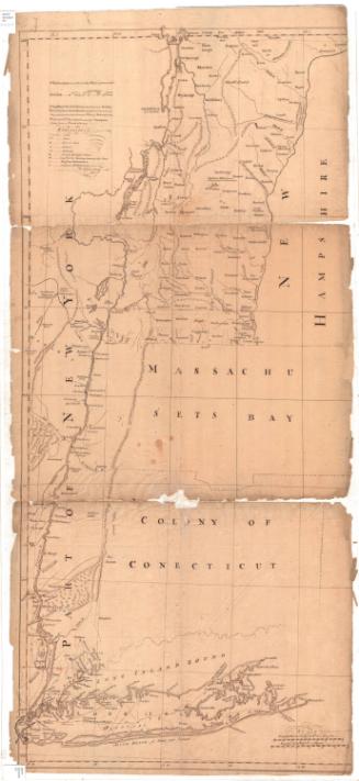
Greenwich, Connecticut at the Time of Ye Revolution 1775-1800
DraftsmanDrawn by
Roger H. Selchow
(American, 1911 - 1995)
Date1939
MediumScreenprint; black ink on paper, mounted on foam core
DimensionsPrimary Dimensions (image height x width): 21 1/4 x 29 1/2in. (54 x 74.9cm)
Sheet (height x width): 25 1/2 x 33in. (64.8 x 83.8cm)
Mount (height x width): 25 1/2 x 33in. (64.8 x 83.8cm)
Sheet (height x width): 25 1/2 x 33in. (64.8 x 83.8cm)
Mount (height x width): 25 1/2 x 33in. (64.8 x 83.8cm)
ClassificationsGraphics
Credit LineConnecticut Museum of Culture and History collection
DescriptionMap of Greenwich, Connecticut, depicted between 1775 and 1800, made to commemorate its 300th anniversary. It shows roads, the homes of prominent citizens, taverns, and cemeteries. Quite a few of the places depicted on the map are related to events that occurred prior to 1775, such as the native Petuquapaen village massacre in 1644. Stars indicate that the building still stands. Natural features include the Mianus River, Long Island Sound, Great Cove, Elizabeth's Neck, and Indian and Horseneck Harbors.
The left border of the map shows historic buildings erected after 1800: Octagon House on Milbank Avenue, the first home of the Brunswick School; the Americus Club in Indian Harbor, the camp of Boss Tweed and Tammany Hall; 206 Milbank Avenue, at which Georges Clemenceau taught school in 1865; the first business building on Greenwich Avenue; the first home of Greenwich Academy; and the Edward Mead home. The right shows "Buildings of great fame and beauty": the YMCA; the fourth building of the Second Congregational Church; America's oldest house, first erected in England in the 16th century and relocated to Greenwich in 1915; the Christ Episcopal Church; the Perrot Memorial Library in Old Greenwich, and the First Congregational Church and June binney Memorial Parish House. The state seal and coat of arms with motto can be found at the bottom left and right corners, respectively. The top border depict the fruits and vegetables that are presumably grown in Greenwich, and the bottom depicts the seafood that can be caught on the shore. On the left side of the cartouche is a man in Revolutionary War dress, including a tricorn hat and a musket. On the left is a Native American, wearing breeches, carrying a spear and holding a net.
The left border of the map shows historic buildings erected after 1800: Octagon House on Milbank Avenue, the first home of the Brunswick School; the Americus Club in Indian Harbor, the camp of Boss Tweed and Tammany Hall; 206 Milbank Avenue, at which Georges Clemenceau taught school in 1865; the first business building on Greenwich Avenue; the first home of Greenwich Academy; and the Edward Mead home. The right shows "Buildings of great fame and beauty": the YMCA; the fourth building of the Second Congregational Church; America's oldest house, first erected in England in the 16th century and relocated to Greenwich in 1915; the Christ Episcopal Church; the Perrot Memorial Library in Old Greenwich, and the First Congregational Church and June binney Memorial Parish House. The state seal and coat of arms with motto can be found at the bottom left and right corners, respectively. The top border depict the fruits and vegetables that are presumably grown in Greenwich, and the bottom depicts the seafood that can be caught on the shore. On the left side of the cartouche is a man in Revolutionary War dress, including a tricorn hat and a musket. On the left is a Native American, wearing breeches, carrying a spear and holding a net.
Object number2012.312.133
NotesCartographic Note: No scaleOn View
Not on view