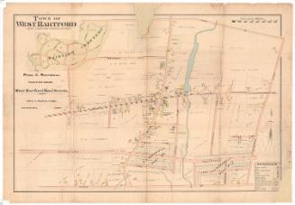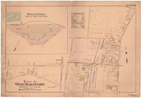
Town of West Hartford, Vanderbilt Hill Section
DraftsmanDrawn by
C. E. Beach
(American, 1862 - 1940)
Date1898
MediumLithography; black printer's ink and watercolor on wove paper, lined with linen
DimensionsPrimary Dimensions (image height x width): 20 1/4 x 30 1/4in. (51.4 x 76.8cm)
Sheet (height x width): 22 1/2 x 32 1/2in. (57.2 x 82.6cm)
Mount (height x width): 22 1/2 x 32 1/2in. (57.2 x 82.6cm)
Sheet (height x width): 22 1/2 x 32 1/2in. (57.2 x 82.6cm)
Mount (height x width): 22 1/2 x 32 1/2in. (57.2 x 82.6cm)
ClassificationsGraphics
Credit LineConnecticut Museum of Culture and History collection
DescriptionMap of part of West Hartford, Connecticut, from Asylum Avenue to the north, Prospect Avenue to the east, Boulevard to the south, and Quaker lane to the west. Above the title is another map, from Boulevard to the north, Prospect Avnue to the east, Park Street to the south, and Quaker Lane to the west. The area of Buena Vista is also shown, at the top left, from Farmington Avenue to the north, Everett Avenue to the east, Park Avenue to the north, and Reservoir 1 to the west. Real estate is shown on all three maps, with lots of land labeled with the owners names and showing buildings of various materials and uses. Farmington Avenue's street-railroad tracks are also depicted. In the top center of the sheet is a references key.
Object number2012.312.131
NotesCartographic Note: Scale: 1 inch equals 300 feet
On View
Not on view