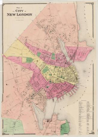
City of Bridgeport, Fairfield County, Connecticut
PublisherPublished by
Beers, Ellis & Soule
(American, active 1865 - 1868)
Date1867
MediumLithography; black printer's ink and watercolor on wove paper
DimensionsPrimary Dimensions (image height x width): 41 1/2 x 29 5/8in. (105.4 x 75.2cm)
Sheet (height x width): 43 1/2 x 31 1/8in. (110.5 x 79.1cm)
ClassificationsGraphics
Credit LineConnecticut Museum of Culture and History collection
Object number2012.312.125
DescriptionStreet map of Bridgeport, Connecticut, extending from North Avenue to the north, the border of Stratford to the east, Seaside Park to the south, and Division Street and the border of Fairfield to the west. Bridgeport's three wards are labeled, and the owners and locations of buildings are given, shaded with different lines to indicate uses. The New York and New Haven and Housatonic Railroads run through the city. The bodies of water on the map are the Pequonnock River, Berkshire Mill Pond, Brdigeport Harbor, Cooks Mill, Pembroke Lake, Stillmans Pond and the Long Island Sound. Bridges include the Yellow Mill Bridge. Parks and cemeteries are colored green and include Walnut Wood, Bridgeport & Stratfield Burial Ground Association, Seaside Park, Washington Park, Hough's Grove, a cemetery, a Roman Catholic cemetery, Pembroke Park, and Old Mill Green. In inset in the bottom left corner of the map shows Mountain Grove Cemetery with its paths and different sections.
Label TextBridgeport, Connecticut was P. T. Barnum's home, and Barnum's stamp on the city is fully evident in this map from the 1860s. Barnum donated the land for Mountain Grove Cemetery in 1849, and was one of the major donors of the land for Seaside Park in 1863 and 1864; both the cemetery and the park appear prominently on this map, and the site of Iranistan, Barnum's Moorish mansion that burned in 1857, and Lindencroft, where he was living in the 1860s are both also indicated. Seaside Park is shown with the seawall and winding drives designed by landscape architect Frederick Law Olmsted in 1867.
Fairfield County, Connecticut has long had close ties with New York City. This map of Bridgeport, Connecticut is a page from Beer's Atlas of New York City and Vicinity, published in New York in 1867 or 1868, suggesting that the County was considered part of the Greater New York area at that early date.
NotesCartographic Note: Scale: 1 inch = 25 rodsFairfield County, Connecticut has long had close ties with New York City. This map of Bridgeport, Connecticut is a page from Beer's Atlas of New York City and Vicinity, published in New York in 1867 or 1868, suggesting that the County was considered part of the Greater New York area at that early date.
Subject Note: The map was most likely published as part of the Atlas of New York and Vicinity: From Actual Surveys. There appear to have been two different editions of the atlas: the 1867 one lists the authors as FW Beers and George E. Warner, and the publication information as "New York, F.W. Beers, A.D. Ellis, and G.G. Soule, 1867;" the 1868 one lists Frederick W. Beers and AB Prindle as the authors, and the publication information as "New York : F.W. Beers, A.D. Ellis & others, 1868."
From WorldCat.
Mountain Grove Cemetery is a rural cemetery laid out in 1849. P. T. Barnum is buried there.
Status
Not on view