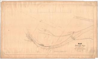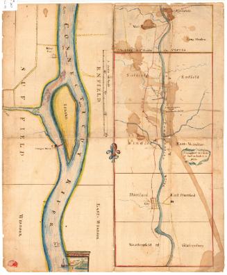
Map of Valuable Real Estate in Windsor Locks, Connecticut
SurveyorSurveyed by
Hiram G. Loomis
(American, 1834 - 1911)
PrinterPrinted by
Kellogg & Bulkeley
(American, 1867 - 1990)
Date1873
MediumLithography; black printer's ink on wove paper
DimensionsPrimary Dimensions (image height x width): 21 1/2 x 33 1/2in. (54.6 x 85.1cm)
Sheet (height x width): 24 1/8 x 35 1/4in. (61.3 x 89.5cm)
ClassificationsGraphics
Credit LineConnecticut Museum of Culture and History collection
Object number2012.312.123
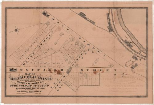
DescriptionMap of part of Windsor Locks, Connecticut, from Main Street to the north, the Connecticut River to the east, Suffield Street to the south, and Olive Street to the west. Numbered lots of land are depicted, with dimensions and, in some cases, shaded rectangles marking the locations of buildings. The Suffield Branch and New York, New Haven and Hartford Railroad lines are depicted running alongside the river, and are decorated with images of trains. Also running parallel to the river is the Enfield Falls Canal (not labeled), which is decorated with a vignette of the Seymour Paper Company. The roads depicted are accompanied by images of horse-drawn carriages.
Label TextAlready in 1873, Windsor Locks, Connecticut was developing as a bedroom suburb of Hartford. An article in the Hartford Courant urged "people wanting homes" to acquire copies of the map showing the "suburban property" in Windsor Locks being offered for sale. The article went on to say that the property has "very easy access to Hartford by very frequent trains and commutation is cheap." The train station is clearly shown on the map, though the proximity of the house lots to the factories of the Seymour Paper Company, the H. C. Douglas & Co. Steam Planing Mill and Lumber Yard, and Coal Yards might seem to be make them somewhat less desirable.
NotesCartographic Note: Scale: 1 inch equals 50 feetStatus
Not on view