Connecticut: Revolutionary War Period
DraftsmanDrawn by
Ed Vebell
(American, born 1921)
After a work byAfter a work by
Bernard Romans
(American, 1741 - 1784)
PublisherPublished by
Ellsworth S. Grant
(American, 1917 - 2013)
Date1976
MediumOffset print; black and colored printer's inks on paper, mounted on card stock
DimensionsPrimary Dimensions (image height x width): 22 1/4 x 28 1/8in. (56.5 x 71.4cm)
Sheet (height x width): 22 1/4 x 28 1/8in. (56.5 x 71.4cm)
Mount (height x width): 22 1/4 x 28 1/8in. (56.5 x 71.4cm)
ClassificationsGraphics
Credit LineConnecticut Museum of Culture and History collection
Object number2012.312.120
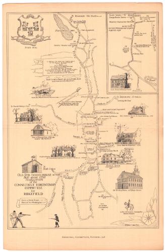
DescriptionMap of Connecticut during the Revolutionary War period, containing symbols and numbers that correspond to a list of symbols and numbers identifying historic houses, museums and Revolutionary War sites, as well as the twelve vignettes around the map. Vignettes depict the execution of Nathan Hale, General Wooster's death at the Battle of Danbury, Putnam's camp in Redding, Salisbury Iron Works, Newgate Prison, Benedict Arnold responding to the Lexington alarm, Washington and Rochambeau meeting in Wethersfield, Governor Jonathan Trumbull providing supplies for Washington's troops, Israel Putnam leaving the plow, the capture of Fort Griswold by the British, American privateers, and the first American submarine, the Turtle.
Label TextLoosely based on an eighteenth-century map by Bernard Romans, this map celebrating Connecticut's contributions to the Revolutionary War was created in 1976, the year of America's Bicentennial. The map itself is less compelling than the vignettes that surround it, and oddly enough does not show any roads, not even Rochambeau's route through the state. The vignettes feature Connecticut's state hero, Nathan Hale, Generals Israel Putnam and David Wooster, Governor Jonathan Trumbull, and even Benedict Arnold, before he turned traitor. They highlight the Salisbury Iron Works, which produced cannon, and Newgate Prison, where Tories and deserters were imprisoned, as well as the Battles of Danbury and Groton Heights. These engaging pictures and the sheer number of revolutionary war sites indicated on the map clearly indicate Connecticut's importance in the conflict.
NotesCartographic Note: No scaleClassification Note: In terms of this project, "historical maps" refer to those made at a later date than the time period depicted.
Status
Not on view