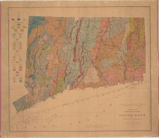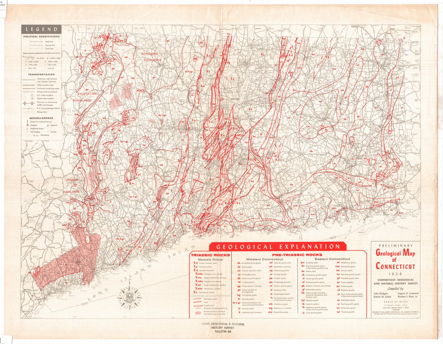
Preliminary Geological Map of Connecticut
MakerCompiled by
John Rodgers
(American, 1914 - 2004)
MakerCompiled by
Eugene N. Cameron
(American, 1910 - 1999)
MakerCompiled by
Robert M. Gates
(American, 1918 - 2004)
MakerCompiled by
Reuben J. Ross Jr.
(American, 1918 - 2005)
Date1956
MediumLithography; red and gray printer's inks on wove paper
DimensionsPrimary Dimensions (image height x width): 19 7/8 x 26 3/4in. (50.5 x 67.9cm)
Sheet (height x width): 22 5/8 x 29in. (57.5 x 73.7cm)
ClassificationsGraphics
Credit LineConnecticut Museum of Culture and History collection
Object number2012.312.119
DescriptionMap of the state of Connecticut, bordered to the north by Massachusetts, the east by Rhode Island, the south by the Long Island Sound, and the west by New York. The different types of Triassic and pre-Triassic rocks in the state are marked on the map with lines and abbreviations of different kinds of rocks, the meanings of which are provided in the "Geological Explanation" below the map. To the left of the map is the legend, which contains explanations for the different lines that mark states, counties and towns; the symbols that denote cities of different sizes; the lines that correspond with different roads and trails; and the symbols that mark elements of infrastructure.
On the verso, there is a much longer explanation of the different types of rocks found in Connecticut than the short key on the recto. It is divided into three categories: pre-Triassic rocks found in Western Connecticut, pre-Triassic rocks found in Eastern Connecticut, and Triassic rocks. The rocks are listed in alphabetical order within categories, and each entry contains information about the physical properties of the rock. In the center of the sheet is a description of the list of sources used in creating the map, and below it is a small map of the state featuring the last names of the authors of those sources in the parts of the state from which the information on the geology came.
On the verso, there is a much longer explanation of the different types of rocks found in Connecticut than the short key on the recto. It is divided into three categories: pre-Triassic rocks found in Western Connecticut, pre-Triassic rocks found in Eastern Connecticut, and Triassic rocks. The rocks are listed in alphabetical order within categories, and each entry contains information about the physical properties of the rock. In the center of the sheet is a description of the list of sources used in creating the map, and below it is a small map of the state featuring the last names of the authors of those sources in the parts of the state from which the information on the geology came.
Label TextA geological map is a special kind of map that shows what is underneath the earth's surface. More recent geological maps, which usually use colors to indicate the different kinds and ages of rocks and are usually printed on top of topographic maps, but this 1956 attempt at a preliminary geological map of Connecticut uses a complicated series of abbreviations and is printed on top of an ordinary road map. The four men involved in compiling this map all went on to distinguished careers in geology. John Rodger, a distinguished professor at Yale University and a specialist on the bedrock geology of Connecticut, published a definitive Bedrock Geological Map of Connecticut in 1988. Robert M. Gates, a professor at the University of Wisconsin in Madison, was a specialist in the geology of western Connecticut and published many books and maps on the subject.
NotesCartographic Note: Scale: 1 inch equals approximately 4 milesStatus
Not on view