Connecticut Map
PublisherPublished by
Connecticut State Highway Department
(American, 1895 - 1969)
PublisherPublished by
State Park and Forest Commission
(American, 1921 - 1971)
PublisherPublished by
State Board of Fisheries and Game
(American, 1913 - 1971)
Date1954
MediumLithography; black and colored printer's inks on wove paper
DimensionsPrimary Dimensions (image height x width): 23 x 31in. (58.4 x 78.7cm)
Sheet (height x width): 23 5/8 x 31 5/8in. (60 x 80.3cm)
Sheet (height x width): 23 5/8 x 31 5/8in. (60 x 80.3cm)
ClassificationsGraphics
Credit LineConnecticut Museum of Culture and History collection
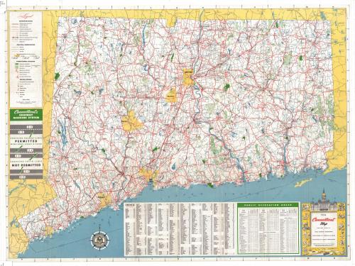
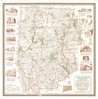
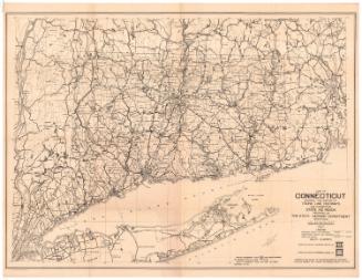
DescriptionMap of the state of Connecticut, with the border of Massachusetts to the north, the border of Rhode Island to the east, the Long Island Sound to the south, and the border of New York to the west. To the left of the map, the legend provides explanations for the depiction of roads, railroads and hiking trails; population centers; state, county and town boundaries; state parks and forests, hunting, fishing and skiing areas; and various elements of infrastructure. Below the legend is a short, illustrated guide to the marking of Connecticut highways. A place name index and list of public recreation areas appear below the map. The cartouche, located in the bottom right corner, shows a variety of Connecticut-related scenes, including the State Capitol building, the state bird and flower, people enjoying the outdoors, and cars on a highway.
On the reverse side, there are eight small maps: one each of New Haven, Bridgeport, Hartford, Waterbury, Danbury, Norwich and New London, and a map of the exits on the Merritt and Wilbur Cross Parkways. To the left of the city maps is a table of approximate mileages from different places in Connecticut, New York, Rhode Island and Massachusetts. The bottom portion of the sheet features nine black-and-white photographs, from left to right: Burr Pond State Park, Harkness Memorial State Park, Gillette Castle State Park, Hammonasset Beach State Park, Devil's Hopyard State Park, Hurd State Park, Rocky Neck State Park, Sleeping Giant State Park, and Sherwood Islands State Park.
On the reverse side, there are eight small maps: one each of New Haven, Bridgeport, Hartford, Waterbury, Danbury, Norwich and New London, and a map of the exits on the Merritt and Wilbur Cross Parkways. To the left of the city maps is a table of approximate mileages from different places in Connecticut, New York, Rhode Island and Massachusetts. The bottom portion of the sheet features nine black-and-white photographs, from left to right: Burr Pond State Park, Harkness Memorial State Park, Gillette Castle State Park, Hammonasset Beach State Park, Devil's Hopyard State Park, Hurd State Park, Rocky Neck State Park, Sleeping Giant State Park, and Sherwood Islands State Park.
Object number2012.312.118
NotesCartographic Note: Scale: 1 inch equals approximately 3.5 milesOn View
Not on view


Connecticut State Highway Department
1934

Connecticut State Highway Department
1927