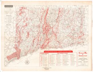
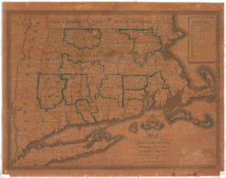
Preliminary Geological Map of Connecticut
MakerMade by
Herbert E. Gregory
(American, 1869 - 1952)
MakerMade by
Henry Hollister Robinson
(American, 1873 - 1925)
PublisherPublished by
State Geological and Natural History Survey of Connecticut
(American, founded 1903)
Date1906
MediumLithography; black and colored printer's inks on wove paper, lined with linen
DimensionsPrimary Dimensions (image height x width): 23 3/4 x 27 1/8in. (60.3 x 68.9cm)
Sheet (height x width): 26 1/8 x 30 1/4in. (66.4 x 76.8cm)
Mount (height x width): 26 1/8 x 30 3/8in. (66.4 x 77.2cm)
Sheet (height x width): 26 1/8 x 30 1/4in. (66.4 x 76.8cm)
Mount (height x width): 26 1/8 x 30 3/8in. (66.4 x 77.2cm)
ClassificationsGraphics
Credit LineConnecticut Museum of Culture and History collection
DescriptionMap of Connecticut's geological features, with contour lines indicating elevation. The map is divided into counties and towns. To the left of the map is a legend which categorizes and color- and line-codes the different types of rocks in the state.
Object number2012.312.117
NotesCartographic Note: Scale: 1/250,000; 1/4 inches equals 1 mileOn View
Not on view