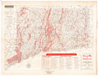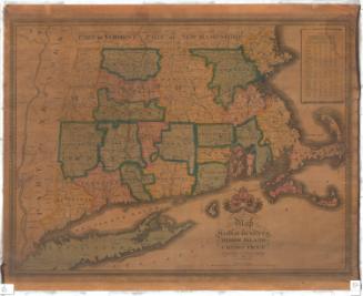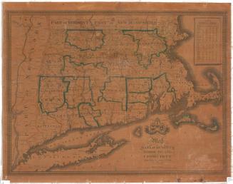
Preliminary Geological Map of Connecticut
MakerMade by
Herbert E. Gregory
(American, 1869 - 1952)
MakerMade by
Henry Hollister Robinson
(American, 1873 - 1925)
PublisherPublished by
State Geological and Natural History Survey of Connecticut
(American, founded 1903)
Date1906
MediumLithography; black and colored printer's inks on wove paper, lined with linen
DimensionsPrimary Dimensions (image height x width): 23 3/4 x 27 1/8in. (60.3 x 68.9cm)
Sheet (height x width): 26 1/8 x 30 1/4in. (66.4 x 76.8cm)
Mount (height x width): 26 1/8 x 30 3/8in. (66.4 x 77.2cm)
ClassificationsGraphics
Credit LineConnecticut Museum of Culture and History collection
Object number2012.312.117
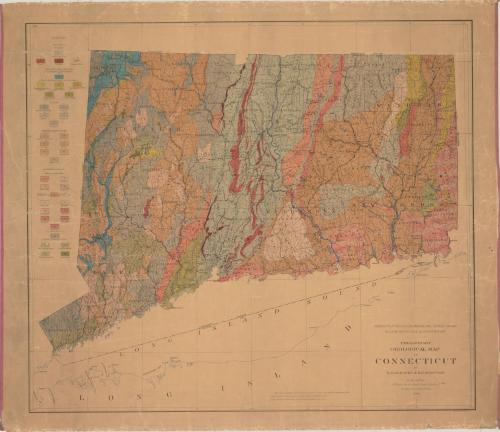
DescriptionMap of Connecticut's geological features, with contour lines indicating elevation. The map is divided into counties and towns. To the left of the map is a legend which categorizes and color- and line-codes the different types of rocks in the state.
Label TextThe Connecticut Geological and Natural History Survey was established in 1903 to study the geology, botany, and zoology of the state. One of the earliest publications of the survey was this Preliminary Geological Map of Connecticut, which uses different colors to illustrate the different types of rocks that make up the state. This important map was first attempt to address the geological makeup of the entire state since James Gates Percival's pioneering 1841 report. Subsequent investigations of the state's geology invariably refer back to these two ground-breaking studies.
NotesCartographic Note: Scale: 1/250,000; 1/4 inches equals 1 mileStatus
Not on view