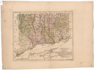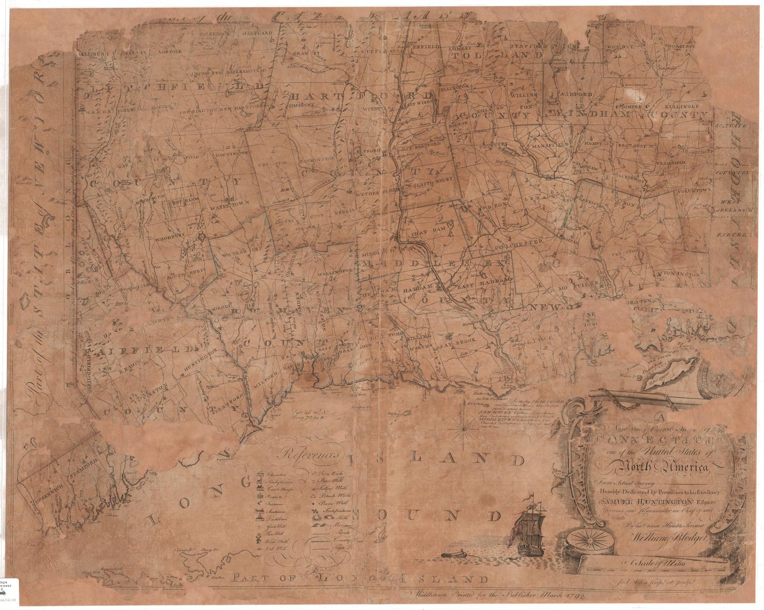
A New and Correct Map of Connecticut, one of the United States of North America
PrintmakerEngraved by
Joel Knott Allen
(American, 1755 - 1825)
PublisherPublished by
William Blodget
(American, 1754 - 1809)
Date1792
MediumEngraving; black printer's ink and watercolor on paper, lined with paper
DimensionsPrimary Dimensions (image height x width): 27 1/2 x 34 5/8in. (69.9 x 87.9cm)
Sheet (height x width): 28 x 35 1/4in. (71.1 x 89.5cm)
Mount (height x width): 28 1/4 x 35 1/4in. (71.8 x 89.5cm)
ClassificationsGraphics
Credit LineConnecticut Museum of Culture and History collection
Object number2012.312.110
DescriptionMap of the state of Connecticut, from the border of Massachusetts to the north, Rhode Island to the east, the Long Island Sound to the south, and New York to the west. The land is divided into counties and towns. Symbols, explained in the References list, are used to denote the locations of churches; "Presbyterians;" courthouses; "Baptists;" furnaces; academies; grist, saw, wind, oil, paper, fulling, and powder mills; iron works, potash works, roads and forts. Elevation is conveyed through hachure marks. Natural features include rivers, lakes and islands. The decorative cartouche features sheaves of wheat and a cylinder with a star or compass on it. To the left of the cartouche is water, presumably representing the Long Island Sound, with a three-masted ship and a rowboat in it. To the top right of the cartouche is part of the state seal, with three grapevines and the state motto.
Label TextConnecticut was one of the first states to be mapped following American independence. William Blodget's New and Correct Map of Connecticut was issued in 1792. The map displays great pride in Connecticut's infant industries, and using symbols and labels to identify distilleries, fulling mills, grist mills, iron works, oil mills, paper mills, potash works, and powder mills throughout the state. This virtually guaranteed that the map would quickly become out-of-date. In addition, Connecticut was growing rapidly during the early Republic. New roads were being built and new towns were being incorporated. This assured that even more than most maps, Blodget's New and Correct Map of Connecticut captures a very specific moment in time.
NotesCondition Note: The Connecticut Historical Society has two copies of this important map. Each copy has significant and different losses. There are two recorded states of this map, but both copies at the Connecticut Historical Society are of the first state.Cartographic Note: Scale: About 1 5/8 inches equals 5 miles
Status
Not on view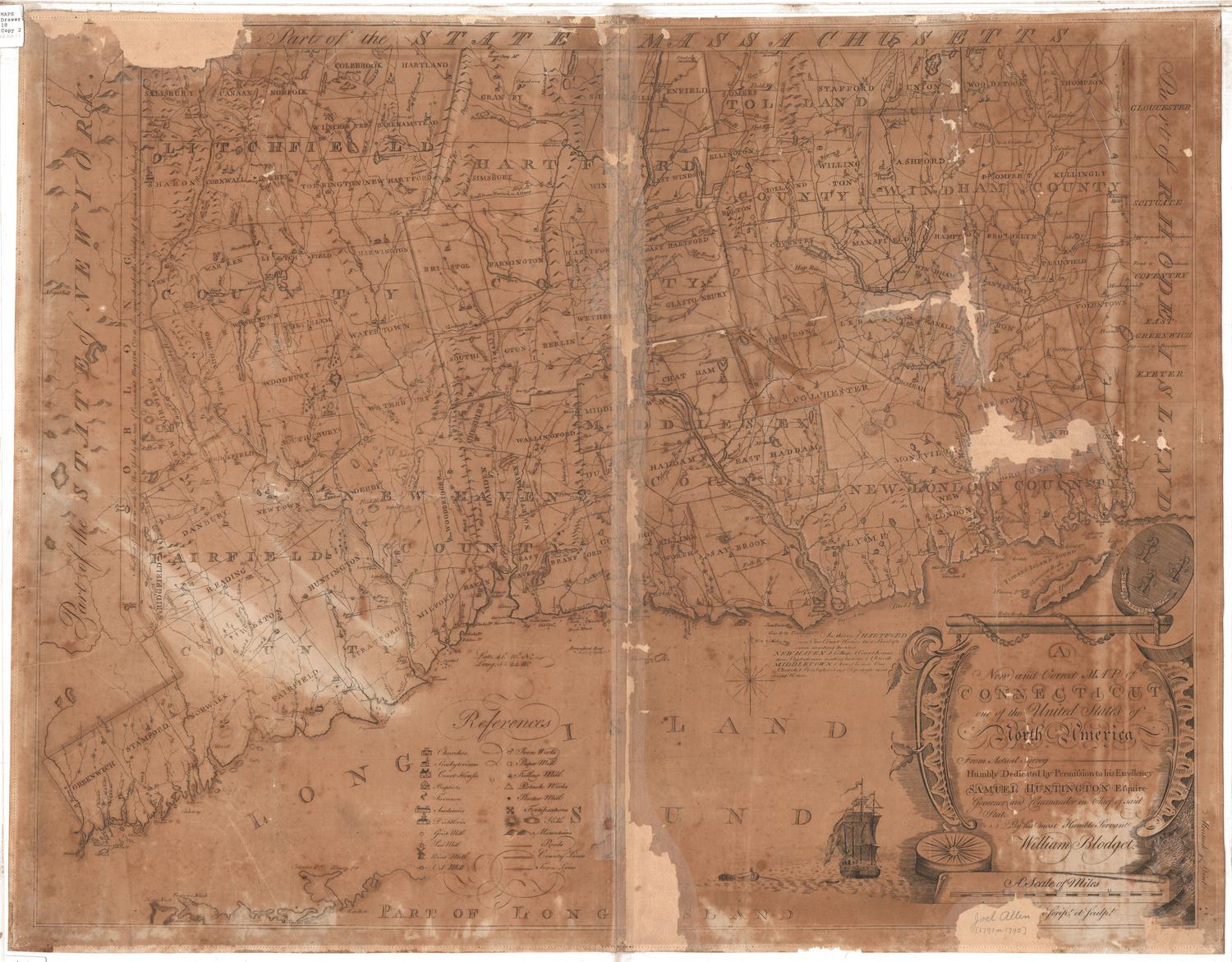
Joel Knott Allen
1791 or 1792