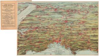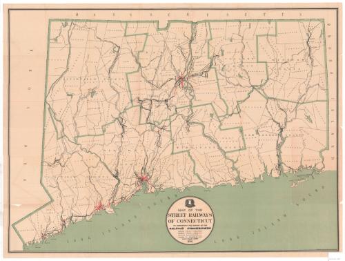
Map of the Street Railways of Connecticut
MakerPrepared by
Frederick L. Ford
(American, 1871 - 1940)
PrintmakerLithographed by
Kellogg & Bulkeley
(American, 1867 - 1990)
PublisherPublished by the
Board of Railroad Commissioners
(American, 1854 - 1911)
Date1901
MediumLithography; black and green printer's inks on wove paper, lined with paper
DimensionsPrimary Dimensions (image height x width): 24 3/8 x 32 3/4in. (61.9 x 83.2cm)
Sheet (height x width): 25 1/2 x 33 5/8in. (64.8 x 85.4cm)
Mount (height x width): 25 1/2 x 33 5/8in. (64.8 x 85.4cm)
ClassificationsGraphics
Credit LineConnecticut Museum of Culture and History collection
Object number2012.312.108
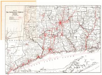
DescriptionMap of Connecticut, from Massachusetts to the north, Rhode Island to the east, the Long Island Sound to the south, and New York to the west. The state is divided into counties and towns, and depicts the locations of its street railways. The different types of tracks -- single and double -- are color-coded, with changes in ownership denoted with a closed circle. Street railway companies labeled on the map include the Stamford Street Railroad; Connecticut Railway and Lighting; the West Shore Railway; the Winchester Avenue Railroad; Fair Haven & Westville Railroad; Branford Electric Railway; Danbury & Bethel Street railway; the Torrington & Winchester Street Railway; Meriden Electric Railroad; Compounce Tram; Middletown Street Railway; Bristol & Plainville Tram; Farmington Street Railway; Hartford Street Railway; Hartford, Manchester & Rockville Tram; Hartford & Springfield Street Railway; Montville Street Railway; Norwich Street Railway; Peoples Tram; and New London Street Railway.
Steam railroads are also depicted and are labeled, including the New York, New Haven and Hartford; Berkshire Branch; Northampton Division; Hartford Division; Highland Division; Air Line Division; Shore Line Division; New London Northern; and Shore Line & Worcester Division Railroads.
Steam railroads are also depicted and are labeled, including the New York, New Haven and Hartford; Berkshire Branch; Northampton Division; Hartford Division; Highland Division; Air Line Division; Shore Line Division; New London Northern; and Shore Line & Worcester Division Railroads.
Label TextThey called it "rapid transit." The term and the concept seem strikingly modern: the use of public transporation to move large numbers of commuters in and out of the city. City Engineer Frederick L. Ford, who drew this map, was closely involved in the development and maintenance of Hartford's street railroad system. At the turn of the nineteenth century, miles of trolley lines connected Hartford with its suburbs, where many of those people who worked in the city's factories and insurance companies now lived. In their off-hours, these same people took the street cars out to suburban trolley parks for recreation. Some of these parks, like West Hartford's Luna Park, were full-fledged amusement parks. Others, like Suburban Park in Unionville and Laurel Park in Manchester offered attractions like dance pavilions and "electric fountains," and a place to stroll beneath the trees. As the automobile increased in affordability and popularity in the early twentieth century, however, more and more working people bought cars and used them to commute to work and to drive out into the countryside on weekends. By the 1940s, Hartford's street railroad system was already a thing of the past. In 1944, Hartford Mayor William L. Mortensen would proudly and symbolically rip up the last of the trolley tracks that only a few years before had run down the middle of so many of Hartford's streets.
NotesCartographic Note: Scale: 1 1/2 inches equals 4 milesStatus
Not on view
Traffic Department, New Haven, Connecticut
1915-1929