Map of Connecticut
PublisherPublished by
Connecticut State Highway Department
(American, 1895 - 1969)
Date1963
MediumColor lithography; black, blue and red printer's ink on wove paper
DimensionsPrimary Dimensions (image height x width): 40 3/8 x 53 5/8in. (102.6 x 136.2cm)
Sheet (height x width): 41 5/8 x 54 3/4in. (105.7 x 139.1cm)
ClassificationsGraphics
Credit LineConnecticut Museum of Culture and History collection
Object number2012.312.107
DescriptionRoad map of the state of Connecticut, including the Long Island Sound, with grid letters at the top and bottom and numbers on both sides. Degrees of longitude and latitude are provided, as well. The legend at the bottom of the sheet provides information about the types of roads marked on the map; interstates, US routes and state routes and their symbols; the political boundary lines for states, towns and counties; symbols marking yacht clubs, airports, heliports and boat launching sites; circles of varying sizes for cities of differing populations; and the scale. There is also a list of public boat launching sites, and an index of cities, towns and places, with their grid coordinates provided. The compass rose, located to the left of the legend, features a shield with three grapevines in it and the Latin phrase "Qui Transtulit Sustinet," which means "He who transplanted still sustains."
Label TextConnecticut's transportation network appears to be maze of red secondary roads and undivided highways on this 1963 map. The interstate highway system is incomplete and difficult to pick out since it is only faintly delineated using thin parallel black lines. The Connecticut Turnpike follows an unfamiliar route diagonally across the state from New York to Massachusetts, and I-95, I-91, I-84 and other major roads are still fragmentary and under construction. This map appears to be a summary of the current state of highway construction in Connecticut rather than a practical road map intended for use by motorists. For some reason, it includes an extensive list of boat launching ramps, but no other recreational faciltiies.
NotesCartographic Note: Scale: 5 inches = 10 milesStatus
Not on view


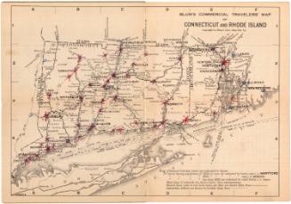
Blum's Commercial Map Publishing Company
1927-1928
