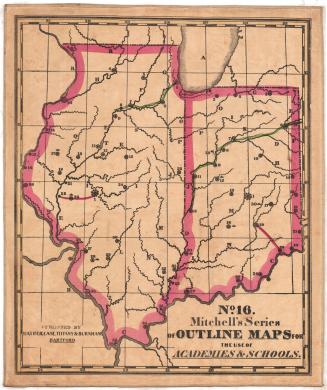
Number 3. Mitchell's Series of Outline Maps for the use of Academies and Schools.
PrinterPrinted by
Samuel Augustus Mitchell
(1792 - 1868)
PublisherPublished by
Mather, Case, Tiffany & Burnham
(American, active 1841)
Date1841
MediumLithograph; black printer's ink and watercolor on wove paper, lined and bound with linen
DimensionsPrimary Dimensions (image height x width): 46 1/4 x 55 3/8in. (117.5 x 140.7cm)
Sheet (height x width): 47 3/4 x 57in. (121.3 x 144.8cm)
Mount (height x width): 47 3/4 x 57in. (121.3 x 144.8cm)
ClassificationsGraphics
Credit LineConnecticut Museum of Culture and History collection
Object number2012.312.105
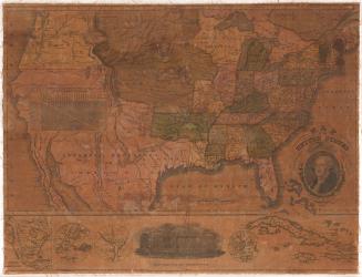
DescriptionTwo maps, one of most of the United States, excluding California, and the other of most of Central America south to Costa Rica. State boundaries are marked with broken solid lines, and national boundaries are marked with broken solid and dotted lines. State capitals are marked with a large circle surrounded by smaller circles (note that Connecticut shows both Hartford and New Haven as capitals). There are numbers and letters that appear on both maps that probably correspond with a workbook or textbook.
Label TextMitchell's maps were designed as visual aids for teaching geography to students. Mitchell believed that the use of maps in the classroom had "produced a new era in the art of teaching. It has established the fact that knowledge communicated to the mind through vision makes the most vivid and lasting impression." A printed key to the maps suggested the kinds of questions that a teacher might ask in order to engage the interest of his or her class. Questions were both general and specific and assumed considerable geographical knowledge on the part of the students. For example, for the map of the United States, questions not only included basic facts like "What are the six New England states?" and "What long range of mountains runs through Vermont and Massachusetts to Connecticut?" but also "What states have produced Presidents, and how many?" and "What natural curiosities are there in the United States?"
NotesCartographic Note: No scaleStatus
Not on view