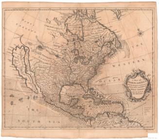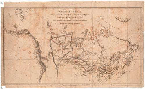
A Map of America
PublisherPublished by
Alexander MacKenzie
(Scottish, 1764 - 1820)
Date1801
MediumEngraving; black printer's ink and red and yellow watercolor on laid paper
DimensionsPrimary Dimensions (image height x width): 17 1/4 x 30 5/8in. (43.8 x 77.8cm)
Platemark (height x width): 31 3/8in. (79.7cm)
Sheet (height x width): 19 1/8 x 31 1/2in. (48.6 x 80cm)
Platemark (height x width): 31 3/8in. (79.7cm)
Sheet (height x width): 19 1/8 x 31 1/2in. (48.6 x 80cm)
ClassificationsGraphics
Credit LineConnecticut Museum of Culture and History collection
DescriptionMap of parts of present-day Canada and the United States, from the 70th parallel north to the north, the Atlantic Ocean to the east, the Great Lakes to the south, and the Bering Strait to the west. It traces explorer Alexander Mackenzie's 1789 route overland from Montreal to the Arctic Ocean through Fort Chipewyan in red, and his 1793 expedition from Montreal to the Pacific Ocean (also through Fort Chipewyan) in yellow. Physical features are depicted and labeled, including elevation, conveyed through hachure marks; lakes; rivers; bays; and islands. The locations of Native American tribes and First Nations peoples are labeled, as well.
Object number2012.312.104
NotesCartographic Note: No scaleOn View
Not on view