
Ornamental Map of the United States & Mexico
PrinterPrinted by
Ensign & Thayer
(American, 1849 - 1850)
PublisherPublished by
Ensign & Thayer
(American, 1849 - 1850)
WriterVignette text written by
Rufus Blanchard
(American, 1822 - 1904)
Date1848
MediumLithography; printer's ink and watercolor on wove paper
DimensionsPrimary Dimensions (image height x width): 29 1/8 x 21in. (74 x 53.3cm)
Sheet (height x width): 31 3/4 x 23 1/8in. (80.6 x 58.7cm)
ClassificationsGraphics
Credit LineConnecticut Museum of Culture and History collection
Object number2012.312.103
DescriptionMap of the United States, Mexico, part of Guatemala and part of the Caribbean islands, from the border of Canada to the north, the Atlantic Ocean to the east, Guatemala to the south, and the Pacific Ocean to the west. The states, including those of Mexico, and countries are outlined in red and colored pink, green or yellow. In the bottom left corner of the map is a list of distances in Mexico. Two columns, one on either side of the map, list the 32 states and territories comprising the United States and provide statistics for each entry on the settlement date, the country settled by, the year admitted into the Union, the population, capital and the population of the capital. The bottom and sides are decorated with a border of stars linked by chains, and at all four corners, there is a shield featuring stars and stripes.
Right above the map, there is a panoramic image from New York to the Pacific Ocean "by the Contemplated Oregon Railroad." The picture is bookended by similar scenes depicting ships sailing off of a coast and in a harbor surrounded by busy factories, respectively. The other scenes show the Rocky Mountains, and what appears to be a university building.
Along the top of the sheet, right below the title, there are three vignettes, with images of General Taylor and General Scott flanking a larger portrait of Washington. The frames around the generals contain various symbols: oak leaves and acorns; shields with a single star and eleven stripes; and two unidentified monuments, one of which appears to be the Washington Monument. Around Washington's portrait are mirror images featuring leafy oak branches laden with acorns, cornucopias or horns of plenty, liberty caps, and the American flag. On the right side of the portrait is a banner that says "Liberty" and the seal of Mexico; on the left, there is a banner that says "Justice" and the reverse of the Great Seal of the United States.
Below the map, there are three more vignettes. On the left, there is an image of Templo Mayor, an Aztec temple, with text describing its physical features and use; on the right is an image of Chapultepec Castle, with accompanying text about the "Halls of Montezuma." In the center, there is a much larger image of a man in fashionable dress, lecturing to the "sovereigns of Europe" about the progress of American shipping, farming, manufacture and exploration.
Label TextThe title of this map makes it clear that it was intended as an ornamental and not as a useful object. It is also a map with a definite poltical agenda, celebrating the success of Generals Zachary Taylor and Winflield Scott in the war with Mexico, juxtaposing their portraits with that of General George Washington. Taylor would be elected President of the United States in 1848, the same year this map was published. The map also celebrates the progress of American industry, even illustrating a "contemplated Oregon railroad," though a transcontinental railroad would not be completed for another twenty years.
Ensign & Thayer and Rufus Blanchard were both occasional partners of E.B. & E.C. Kellogg, the largest and most successful lithography firm in Hartford, Connecticut. Their Ornamental Map of the United States & Mexico is an interesting comparison to the Kelloggs' 1847 Map of Mexico, Texas and California (2012.312.82).
NotesCartographic Note: Scale: 1 1/2 inches equals 300 milesEnsign & Thayer and Rufus Blanchard were both occasional partners of E.B. & E.C. Kellogg, the largest and most successful lithography firm in Hartford, Connecticut. Their Ornamental Map of the United States & Mexico is an interesting comparison to the Kelloggs' 1847 Map of Mexico, Texas and California (2012.312.82).
Status
Not on view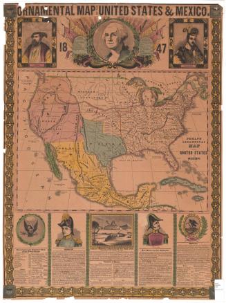


Object/Object
