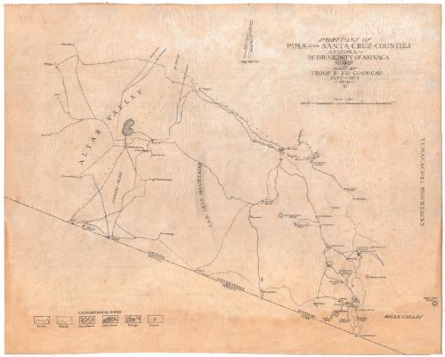
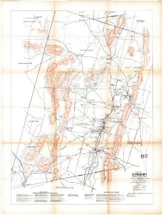
Portions of Pima and Santa Cruz Counties, Arizona
DraftsmanDrawn by
Unknown
Date1916
MediumDrawing; ink and pencil on linen
DimensionsPrimary Dimensions (image height x width): 23 x 28 1/2in. (58.4 x 72.4cm)
Sheet (height x width): 23 x 28 1/2in. (58.4 x 72.4cm)
ClassificationsGraphics
Credit LineConnecticut Museum of Culture and History collection
Object number2012.312.101
DescriptionManuscript map of the physical features, mines, and camps in Pima and Santa Cruz counties, Arizona, extending from Ronstadt to the north, the Tumacacori Mountains to the west, the United States-Mexico border to the south, and Altar Valley to the west. The key, found in the lower left corner, explains the symbols for roads, trails, fresh marshes, lakes or ponds, villages, and corrals. Elevation is conveyed with hachure marks. At the top of the map, there are two north arrows, one marking magnetic north and the other marking true north.
Label TextOn 9 March 1916, Mexican revolutionaries attacked the border town of Columbus, New Mexico. President Woodrow Wilson reacted quickly, dispatching the United States army to hunt for Pancho Villa, the leader of the revolutionaries. These troops included the Connecticut Governor's Horse Guard (Troop B of the Connecticut National Guard before being called to active service), which served with the Fifth Connecticut Cavalry. Troop B spent its time guarding the border and compiling this map. Captain J. H. K. Davis reported regularly on the map's progress. On September 16, 1916, he wrote that "A patrol of six men under my command spent five days during the past week and the previous week gathering data for map.... I wish to report progress on this map, but owing to the difficult character of the ground to be covered, it will be some time before the map is completed." And on October 1, he continued, "Data for map is still being gathered and during the coming two weeks, a portion of this patrol (under Lieutenant Morgan G. Bulkeley) will give their time exclusively to mapping." Troop B left Arizona shortly afterwards, apparently without completing the map.
NotesCartographic Note: Scale: 1 inch equals 1 mileStatus
Not on view

1936-1944