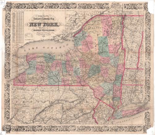
Colton's Railroad and Township Map of the State of New York
DraftsmanDrawn by
George W. Colton
(American, 1827 - 1901)
PrintmakerEngraved by
J. M. Atwood
(American, active about 1840 - 1875)
PublisherPublished by
J. H. Colton & Co.
(American, founded 1831)
Date1856
MediumEngraving; black printer's ink and watercolor on wove paper
DimensionsPrimary Dimensions (image height x width): 25 x 28 1/4in. (63.5 x 71.8cm)
Sheet (height x width): 25 1/4 x 28 3/4in. (64.1 x 73cm)
ClassificationsGraphics
Credit LineConnecticut Museum of Culture and History collection
Object number2012.312.100
DescriptionMap of the state of New York, from part of Ontario, Canada, to the north; Vermont and parts of Massachusetts and Connecticut to the east; parts of Pennsylvania and New Jersey to the south; and Lake Erie to the west. New York is divided into counties, colored pink, blue or yellow and separated by broken solid lines; and towns, separated by thin solid lines. The counties and towns of the adjoining states are similarly depicted, without color. Railroad lines shown include the New York and Erie; Buffalo and New York City; Buffalo, Corning and New York; Niagara Falls; Rochester and Syracuse Direct; Williamsport and Elmira; Syracuse and Binghamton; Watertown and Rome; Central; New York and Harlem; and the Hudson River Railroads. Also shown are canals. Physical features depicted include elevation, conveyed through hachure marks, rivers, lakes and islands. In the top left corner is a list of New York counties, their populations in 1840 and 1850, the number of farms and "productive establishments."
Label TextColton's Railroad an Township Map of the State of New York doesn't stop at the state line. It shows the connecting railroad lines in adjoining states, including Connecticut. The extent of the railway network in the decade before the Civil War is impressive, with many lines that no longer exist today. A charming feature of this map is the way certain geographical features break through the decorative border. These include the east end of Long Island, the Saint Lawrence River as far as Montreal, and Erie, County, Pennsylvania. It was necessary to include these features in order to show the termini of important railroad lines; allowing them to extend through the borders allowed the mapmakers to make the central section of the map larger than it otherwise would have been and thus to provide greater detail and clarity.
NotesDate Note: Map is apparently a re-issue of a map originally published in 1852.Cartographic Note: 1/2 inch equals about 8 miles
Status
Not on view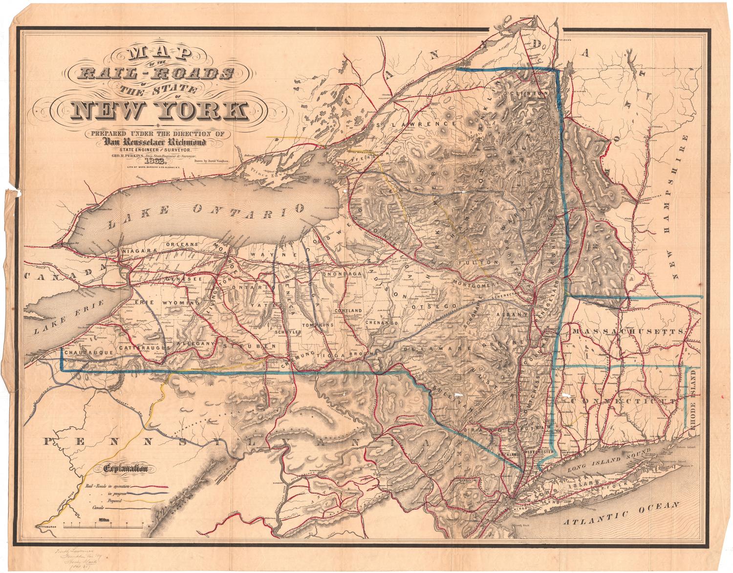
Lucius Stebbins & Co.
1859