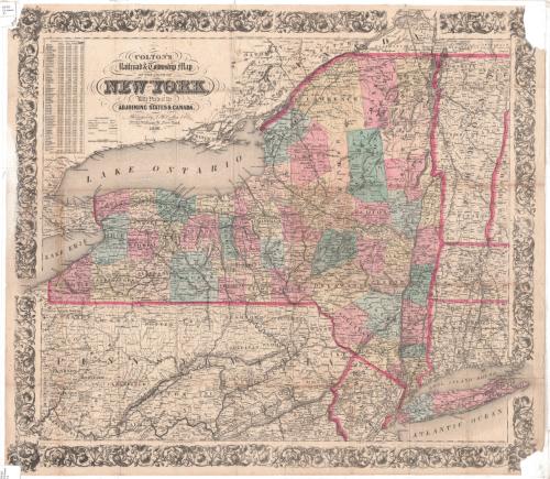
Colton's Railroad and Township Map of the State of New York
DraftsmanDrawn by
George W. Colton
(American, 1827 - 1901)
PrintmakerEngraved by
J. M. Atwood
(American, active about 1840 - 1875)
PublisherPublished by
J. H. Colton & Co.
(American, founded 1831)
Date1856
MediumEngraving; black printer's ink and watercolor on wove paper
DimensionsPrimary Dimensions (image height x width): 25 x 28 1/4in. (63.5 x 71.8cm)
Sheet (height x width): 25 1/4 x 28 3/4in. (64.1 x 73cm)
Sheet (height x width): 25 1/4 x 28 3/4in. (64.1 x 73cm)
ClassificationsGraphics
Credit LineConnecticut Museum of Culture and History collection
DescriptionMap of the state of New York, from part of Ontario, Canada, to the north; Vermont and parts of Massachusetts and Connecticut to the east; parts of Pennsylvania and New Jersey to the south; and Lake Erie to the west. New York is divided into counties, colored pink, blue or yellow and separated by broken solid lines; and towns, separated by thin solid lines. The counties and towns of the adjoining states are similarly depicted, without color. Railroad lines shown include the New York and Erie; Buffalo and New York City; Buffalo, Corning and New York; Niagara Falls; Rochester and Syracuse Direct; Williamsport and Elmira; Syracuse and Binghamton; Watertown and Rome; Central; New York and Harlem; and the Hudson River Railroads. Also shown are canals. Physical features depicted include elevation, conveyed through hachure marks, rivers, lakes and islands. In the top left corner is a list of New York counties, their populations in 1840 and 1850, the number of farms and "productive establishments."
Object number2012.312.100
NotesDate Note: Map is apparently a re-issue of a map originally published in 1852.
Cartographic Note: 1/2 inch equals about 8 milesOn View
Not on view

Lucius Stebbins & Co.
1859