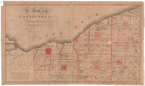
A Map of the Connecticut Western Reserve, from actual Survey
SurveyorSurveyed by
Seth Pease
(American, 1774 - 1819)
MakerUpdated by
Abraham Tappan
(American, 1759 - 1855)
PrintmakerEngraved by
Amos Doolittle
(American, 1754 - 1832)
Date1798
MediumEngraving; black printer's ink and color on paper, lined with paper
DimensionsPrimary Dimensions (image height x width): 19 x 32 1/2in. (48.3 x 82.6cm)
Sheet (height x width): 20 x 33 3/4in. (50.8 x 85.7cm)
Mount (height x width): 20 x 33 3/4in. (50.8 x 85.7cm)
ClassificationsGraphics
Credit LineConnecticut Museum of Culture and History collection
Object number2012.312.99
DescriptionMap of the Connecticut Western Reserve in what is now Ohio, from Sandusky Bay and Lake Erie to the north, Ashtabula and Trumbull counties to the east, Medina and Portage counties to the south, and the Fire Land to the west. The other counties depicted are Lorain, Cuyahoga and Geauga. All counties are outlined in red and each county seat is colored red. The land is divided into named townships or numbered ranges. The Fire Land (now Firelands), directly west of the Western Reserve, contains no divisions. Rivers, lakes, bays and paths are also included on the map.
Label TextAccording to Connecticut's original colonial charter, the western boundary of the state reached all the way to the Pacific Ocean. In 1786, the new Federal government granted Connecticut a strip of territory along Lake Erie in return for relinquishing its other western land claims. This area, known as the Western Reserve, later became part of the state of Ohio. Seth Pease, a surveyor from Suffield, Connecticut, was a member of the first surveying expedition sent out to the Western Reserve by the Connecticut Land Company in 1796. Pease engaged Amos Doolittle, a New Haven engraver, to produce the first printed map of the territory in 1798.
NotesCartographic Note: No scaleStatus
Not on view


Thomas Sedgwick Steele
1881


Object/Object