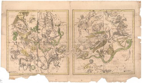
Map of the Constellations
PrintmakerEngraved by
W. G. Evans
(American, active 1835)
MakerCorrected by
Elijah H. Burritt
(American, 1794 - 1838)
PublisherPublished by
Francis Junius Huntington
(American, 1802 - 1878)
Date1835
MediumEngraving; black printer's ink and watercolor on wove paper
DimensionsPrimary Dimensions (image height x width): 13 15/16 x 27 1/8in. (35.4 x 68.9cm)
Platemark (height x width): 16 x 28 1/8in. (40.6 x 71.4cm)
Sheet (height x width): 17 1/2 x 29 3/4in. (44.5 x 75.6cm)
ClassificationsGraphics
Credit LineConnecticut Museum of Culture and History collection
Object number2012.312.96
DescriptionTwo side-by-side maps of the night sky, with stars of varying sizes, including clusters and nebulas, and depictions of the constellations. The map on the left side shows the constellations in the September, August and July sky, with the solstitial and equinoctial colures, and line of the earth's orbit. The map on the right shows the constellations in the June, May and April sky, with two equinoctial colures and the line of the earth's orbit. Only some of the constellations are colored; the significance of this is unknown.
Label TextThese two plates served as illustrations in Elijah H. Burritt's Geography of the Heavens, published by F. J. Huntington in Hartford, Connecticut. Burritt, a school teacher from New Britain, Connecticut, published several textbooks on astronomy that were intended to engage students in the study of astronomy. His Geography of the Heavens was immensely popular and went through several editions between 1833 and 1856. The plates are still much admired for their fanciful representations of the constellations and have been frequently reprinted and reproduced.
NotesCartographic Note: No scaleStatus
Not on view


James Liddell Goldie
1927