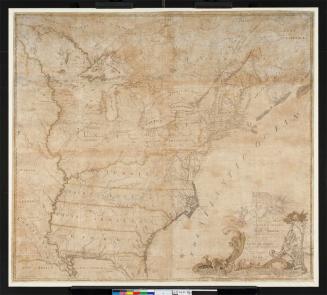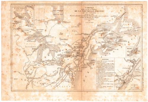
Cartes pour servir a l'Histoire de la Nouvelle-France ou du Canada
MakerCompiled by
Louis Dussieux
(French, 1815 - 1894)
Date1851
MediumEngraving; black printer's ink on wove paper
DimensionsPrimary Dimensions (image height x width): 7 1/2 x 11 3/8in. (19.1 x 28.9cm)
Sheet (height x width): 8 5/8 x 12 5/8in. (21.9 x 32.1cm)
Sheet (height x width): 8 5/8 x 12 5/8in. (21.9 x 32.1cm)
ClassificationsGraphics
Credit LineConnecticut Museum of Culture and History collection
DescriptionMap of Canada and the United States, from Hudson's Bay to the north, the Atlantic Ocean to the east, the Carolinas to the south, and the Great Lakes to the west, primarily chronicling the French and Indian War. Three inset maps depict French forts on Hudson's Bay, Montreal, and the area around Quebec. The Quebec inset details various battles and military maneuvers in 1759, as explained by the legend.
Object number2012.312.90
NotesCartographic Note: No scaleOn View
Not on view