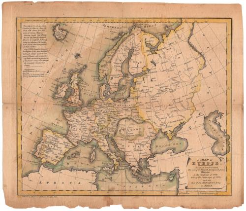
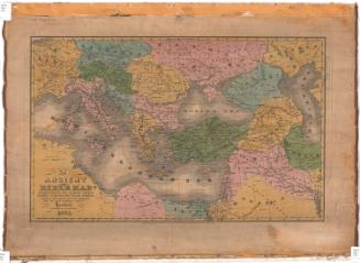
A Map of Europe
PrintmakerEngraved by
Abner Reed
(American, 1771 - 1866)
PrinterPrinted by
Abner Reed
(American, 1771 - 1866)
PublisherPublished by
Abner Reed
(American, 1771 - 1866)
Date1814
MediumEngraving; black printer's ink and watercolor on wove paper
DimensionsPrimary Dimensions (image height x width): 10 3/4 x 12 7/8in. (27.3 x 32.7cm)
Platemark (height x width): 12 1/8 x 13 5/8in. (30.8 x 34.6cm)
Sheet (height x width): 12 1/2 x 14 1/2in. (31.8 x 36.8cm)
Platemark (height x width): 12 1/8 x 13 5/8in. (30.8 x 34.6cm)
Sheet (height x width): 12 1/2 x 14 1/2in. (31.8 x 36.8cm)
ClassificationsGraphics
Credit LineConnecticut Museum of Culture and History collection
DescriptionMap of Europe, from Iceland to the north, the Caspian Sea to the east, Africa to the south, and the Atlantic Ocean to the west. Through the use of lines to denote various routes, the map depicts Napoleon's route from Paris to Moscow and his retreat from Moscow to Frankfurt, Napoleon's route between Mentz and Breslau in 1813, and Lord Wellington's route in Spain. There are several unexplained dotted lines that appear both on land and in the water, and one solid line tracing St. Paul's journey from Caesarea to Rome. Lines of latitude and longitude appear on the map, and their degree numbers are inscribed in the borders.
Object number2012.312.89
NotesCartographic Note: No scaleOn View
Not on view
Ithamar P. Berthrong
1908