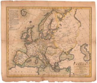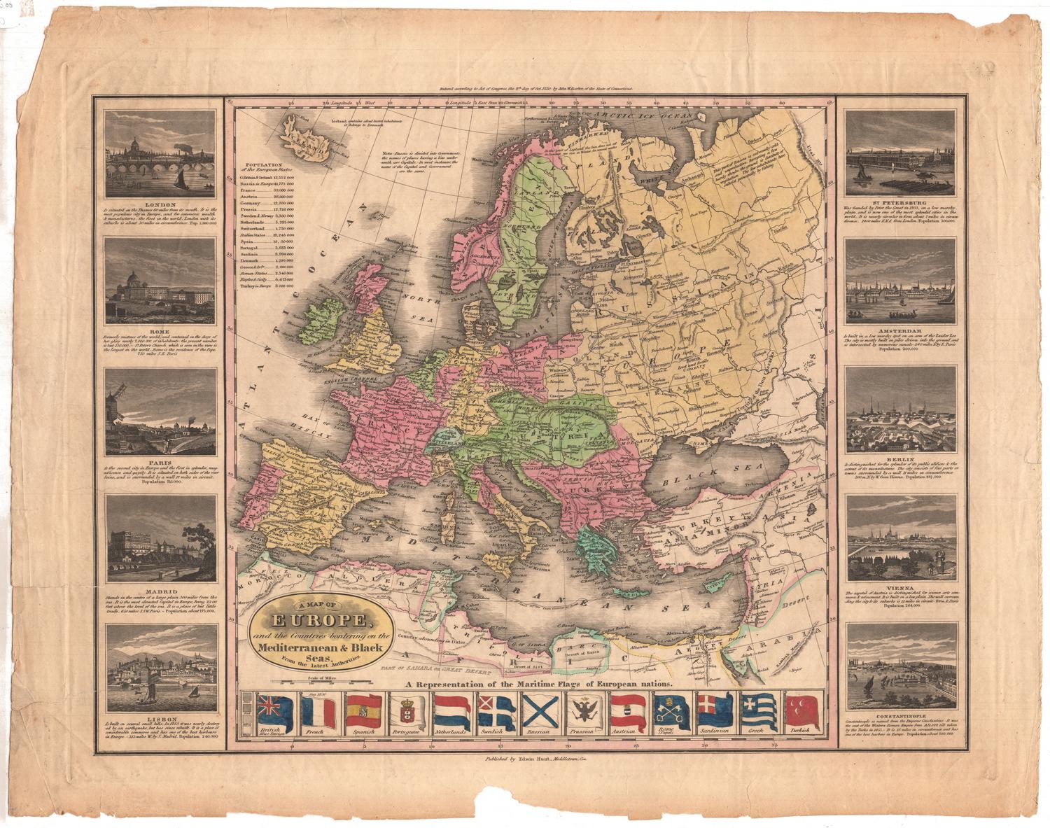
A map of Europe and the Countries bordering on the Mediterranean and Black Seas, From the latest Authorities
DraftsmanProbably drawn by
John Warner Barber
(American, 1798 - 1885)
PrintmakerProbably engraved by
John Warner Barber
(American, 1798 - 1885)
PrinterProbably printed by
John Warner Barber
(American, 1798 - 1885)
PublisherPublished by
Edwin Hunt
(American, about 1801 - 1854)
MakerCopyrighted by
John Warner Barber
(American, 1798 - 1885)
Date1830
MediumEngraving; black printer's inks and watercolors on wove paper
DimensionsPrimary Dimensions (image height x width): 15 13/16 x 20 3/4in. (40.2 x 52.7cm)
Platemark (height x width): 17 1/4 x 22 1/8in. (43.8 x 56.2cm)
Sheet (image height x width): 19 3/8 x 24 3/8in. (49.2 x 61.9cm)
Platemark (height x width): 17 1/4 x 22 1/8in. (43.8 x 56.2cm)
Sheet (image height x width): 19 3/8 x 24 3/8in. (49.2 x 61.9cm)
ClassificationsGraphics
Credit LineConnecticut Museum of Culture and History collection
DescriptionMap of Europe and parts of the Middle East and Africa, from Iceland to the north, Armenia to the east, Tripoli to the south, and the Atlantic Ocean to the west. Settlements are marked with circles and labeled, and rivers are labeled. There are several routes, denoted with dotted lines and unlabeled, that are probably exploration and discovery or military routes. The one water route shows St. Paul's journey from Caesarea to Rome. To the left of the map is a list of the populations of the European countries. Below the map are the flags of Britain, France, Spain, Portugal, the Netherlands, Sweden, Russia, Prussia, Austria, Rome, Sardinia, Greece and Turkey, and they have been colored in; next to the flags is a key explaining how the different types of shading correspond to different colors. Around the map on the left and right sides are, in clockwise order, vignettes of St. Petersburg, Amsterdam, Berlin, Vienna, Constantinople, Lisbon, Madrid, Paris, Rome and London. A brief description of each city and its population size are provided beneath each vignette.
Object number2012.312.88
NotesConstituent Note: John Warner Barber's role in this map is not clearly spelled out in the inscriptions on it, but he was probably the artist, engraver, and printer as well the copyright holder. Barber was multi-talented and often served in all these roles and also as the publisher of his books and prints. This map of Europe was published by Edwin Hunt in Middletown, rather than by Barber himself. It is possible that Hunt commissioned the map from Barber, or that he supplied funds for the map's publication. Hunt later appears in Hartford as a bookseller and publisher.On View
Not on view