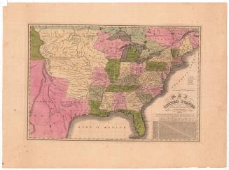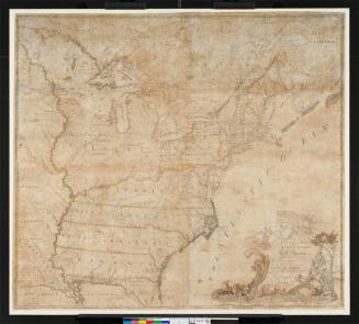


A Map of the United States and British Provinces of Upper and Lower Canada with other parts adjacent
PrintmakerEngraved by
Amos Doolittle
(American, 1754 - 1832)
PrintmakerEngraved by
Thomas Kensett
(American, 1786 - 1829)
PrinterPrinted by
Shelton & Kensett
(American, founded 1813)
Date1816
MediumEngraving; black printer's ink and watercolor on paper, lined with linen
DimensionsPrimary Dimensions (.a image height x width): 23 1/8 x 17 3/4in. (58.7 x 45.1cm)
Sheet (.a height x width): 23 3/4 x 18 3/8in. (60.3 x 46.7cm)
Mount (.a height x width): 24 x 18 5/8in. (61 x 47.3cm)
Primary Dimensions (.b image height x width): 23 1/2 x 18 1/2in. (59.7 x 47cm)
Sheet (.b height x width): 24 x 18 1/2in. (61 x 47cm)
Mount (.b height x width): 24 1/8 x 18 5/8in. (61.3 x 47.3cm)
Primary Dimensions (.c image height x width): 23 1/2 x 17 5/8in. (59.7 x 44.8cm)
Sheet (.c height x width): 24 x 18 1/2in. (61 x 47cm)
Mount (.c height x width): 24 1/4 x 18 5/8in. (61.6 x 47.3cm)
Primary Dimensions (.d image height x width): 23 1/2 x 18in. (59.7 x 45.7cm)
Sheet (.d height x width): 25 1/8 x 18 1/2in. (63.8 x 47cm)
Mount (.d height x width): 25 1/2 x 18 3/4in. (64.8 x 47.6cm)
Primary Dimensions (.e image height x width): 23 1/2 x 18 1/2in. (59.7 x 47cm)
Sheet (.e height x width): 25 3/8 x 18 1/2in. (64.5 x 47cm)
Mount (.e height x width): 25 5/8 x 18 5/8in. (65.1 x 47.3cm)
Primary Dimensions (.f image height x width): 23 1/2 x 17 3/4in. (59.7 x 45.1cm)
Sheet (.f height x width): 25 3/8 x 18 1/4in. (64.5 x 46.4cm)
Mount (.f height x width): 25 3/8 x 18 5/8in. (64.5 x 47.3cm)
ClassificationsGraphics
Credit LineConnecticut Museum of Culture and History collection
Object number2012.312.87
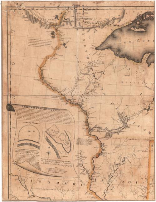
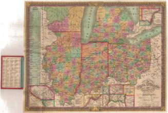
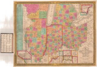
DescriptionMap of the United States and Canada, from Upper and Lower Canada to the north; the Atlantic Ocean to the east; Louisiana, Mississippi and Georgia to the south, and Louisiana to the west. State, territory and country boundary lines are outlined in color. Smaller land divisions include districts, counties and towns, ranges, purchases and divisions. Roads are included. Natural features consist of mountain ranges, drawn in relief; lakes; bays; rivers; waterfalls; and islands. Lands inhabited or hunted on by Native Americans are also labeled. The Missouri, St. Lawrence and Mississippi Rivers are all labeled with a brief, descriptive paragraph. The decorative cartouche features Niagara Falls complete with rainbow and mist, and two Native Americans, one with a weapon, on the rocky ledge overlooking the falls. Below the cartouche is a description of Niagara Falls. To the left of the map is a text block titled, "Remnants of Antiquity," which describes monuments found in Ohio and Indiana Territory.
Label TextShelton & Kensett were unusually explicit in identifying the sources for the small pictures in the lower corners of their huge map of the United States and Canada. The inscription accompanying the cartouche states that "This view of the Falls of Niagara is Engraved from Tardieus Map Published in Paris." A "Plan and Description of an Ancient Work" is credited to "Mr. Enos Cutler, Deputy Surveyor," and they even explain that the "Plan of the Ancient Works at Marietta" was taken by "the Hon. Gen. Parsons and Communicated to the Rev. Doctor Stiles President of Yale College," who presumably made the drawing available to the mapmakers. Shelton & Kensett do not, however, explain that the map itself is closely based on Pierre Francois Tardieu's map, that it makes use of Abraham Bradley's postal maps, or that it incorporates recent discoveries by Zebulon Pike. Such unattributed borrowings were common in early maps. With its large scale and wealth of detailed, up-to-date information, the Shelton & Kensett map is a remarkable production for a couple of engravers working in remote, rural Chesire, Connecticut.
NotesCartographic Note: Scale: 1 inch equals about 30 milesDimensions Note: The map is composed of six pieces. Dimensions for each piece are listed separately.
Status
Not on view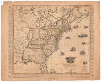

Samuel Augustus Mitchell
1834
Samuel Augustus Mitchell
1835