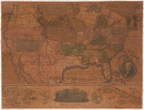
Map of the United States Compiled from the most Authentic sources
PublisherPublished by
Willis Thrall
(American, 1800 - 1884)
Date1831
MediumEngraving; black printer's ink and watercolor on paper, lined with linen
DimensionsPrimary Dimensions (image height x width): 19 5/8 x 26 1/4in. (49.8 x 66.7cm)
Sheet (height x width): 20 x 26 1/4in. (50.8 x 66.7cm)
Mount (height x width): 20 x 26 1/4in. (50.8 x 66.7cm)
ClassificationsGraphics
Credit LineConnecticut Museum of Culture and History collection
Object number2012.312.84
DescriptionMap of the United States and part of the Caribbean, including continental territories, with the states and territories colored green, pink or yellow. Towns, courthouses and rivers are labeled on the map. Relief is conveyed with hachure marks. A chart shows the distances from the capital or largest town of each state to Washington, D.C., and between the capitals or towns. The decorative cartouche contains a portrait of George Washington, above which there is an eagle holding an olive branch, arrows and a shield. Around Washington's portrait are two oak branches with leaves and acorns. Below the main map there are inset maps of North America, New York City, the District of Columbia, and Boston. Also below the main map, there is a vignette depicting the United States Capitol. Lines of latitude and longitude are marked.
Label TextDuring the 1830s, Willis Thrall, a Hartford businessman, dabbled in print and map publishing and produced some large and impressive prints and maps. For this map of the United States, Thrall evidently obtained the copperplate that had been engraved by Asaph Willard and published by Eleazer Huntington and Willard in 1826, and simply reprinted it, substituting his own name as publisher. The interior of the west was so little known, and apparaently of so little interest, that the original mapmaker used this space for a chart showing the distances between the state capitals and Washington, D.C..
NotesCartographic Note: Scale: 7/8 of an inch equals about 100 milesHartford in the nineteenth century was a major center of printing and publishing. Willis Thrall published books, maps, and prints during the 1830s and 1840s, listing himself as a map publisher in the Hartford city directories for some years. He later became a hardware and rule manufacturer.
Status
Not on view


Object/Object