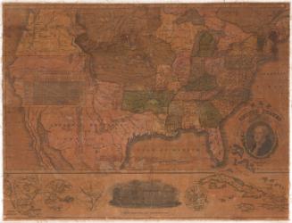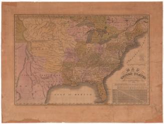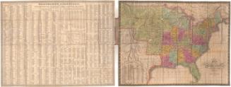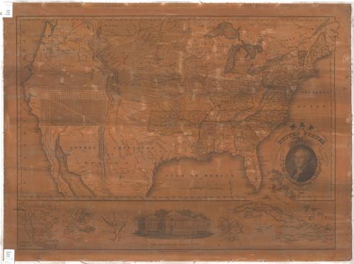
Map of the United States
PrintmakerEngraved by
Asaph Willard
(1786 - 1880)
PublisherPublished by
Eleazer Huntington
(American, 1789 - 1852)
PublisherPublished by
Asaph Willard
(1786 - 1880)
Date1826
MediumEngraving; black printer's ink and watercolor on paper, lined with linen
DimensionsPrimary Dimensions (image height x width): 19 5/8 x 26 1/2in. (49.8 x 67.3cm)
Sheet (height x width): 21 5/8 x 28 7/8in. (54.9 x 73.3cm)
Sheet (height x width): 21 5/8 x 28 7/8in. (54.9 x 73.3cm)
ClassificationsGraphics
Credit LineConnecticut Museum of Culture and History collection
DescriptionMap of the United States and part of the Caribbean, including continental territories. Towns are marked with circles and state capitals with starred circles. Geographic features include rivers, mountains, lakes and swamps. Relief is conveyed with hachure marks. A chart showing the distances from the capital or largest town of each state to Washington, D.C., and between the capitals or towns. The decorative cartouche contains a portrait of George Washington, above which there is an eagle holding an olive branch, arrows and a shield. Around Washington's portrait are two oak branches with leaves and acorns. Below the main map there are inset maps of North America, New York City, the District of Columbia, and Boston. Also below the main map, there is a vignette depicting the United States Capitol. Lines of latitude and longitude are marked.
Object number2012.312.83
NotesCartographic Note: Scale: Almost 3 3/8 inches equals 400 milesOn View
Not on view