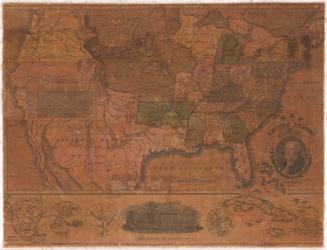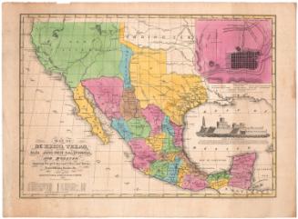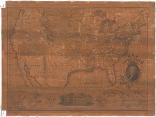
Map of the United States
PrintmakerEngraved by
Asaph Willard
(1786 - 1880)
PublisherPublished by
Eleazer Huntington
(American, 1789 - 1852)
PublisherPublished by
Asaph Willard
(1786 - 1880)
Date1826
MediumEngraving; black printer's ink and watercolor on paper, lined with linen
DimensionsPrimary Dimensions (image height x width): 19 5/8 x 26 1/2in. (49.8 x 67.3cm)
Sheet (height x width): 21 5/8 x 28 7/8in. (54.9 x 73.3cm)
ClassificationsGraphics
Credit LineConnecticut Museum of Culture and History collection
Object number2012.312.83
DescriptionMap of the United States and part of the Caribbean, including continental territories. Towns are marked with circles and state capitals with starred circles. Geographic features include rivers, mountains, lakes and swamps. Relief is conveyed with hachure marks. A chart showing the distances from the capital or largest town of each state to Washington, D.C., and between the capitals or towns. The decorative cartouche contains a portrait of George Washington, above which there is an eagle holding an olive branch, arrows and a shield. Around Washington's portrait are two oak branches with leaves and acorns. Below the main map there are inset maps of North America, New York City, the District of Columbia, and Boston. Also below the main map, there is a vignette depicting the United States Capitol. Lines of latitude and longitude are marked.
Label TextMost nineteenth-century American maps depict very specific moment's in the Nation's history. The Missouri Compromise of 1820 had admitted Missouri to the Union as a slave state, but excluded slavery from the Missouri Territory above 36 degrees 30 minutes except within the borders of the new state. The territory below this line became Arkansas Territory, and slavery was permitted there. This 1826 map printed and published in Hartford shows Arkansas Territory with its original boundaries, despite the fact that the western portion of the territory had been detached in 1824 to serve as Indian Territory. The rapid changes that were taking place as new states and territories were created made it hard for nineteenth-century mapmakers to keep their maps accurate and up-to-date.
NotesCartographic Note: Scale: Almost 3 3/8 inches equals 400 milesStatus
Not on view