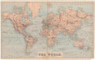
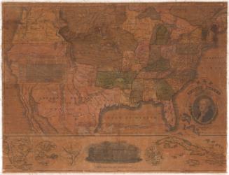
A map of the Travels of George Washington
PublisherPublished by
National Geographic Society (U. S.)
(American, founded 1888)
Date1931
MediumOffset lithography; black and colored printer's inks on wove paper
DimensionsPrimary Dimensions (image height x width): 28 1/8 x 19 1/8in. (71.4 x 48.6cm)
Sheet (height x width): 29 x 20in. (73.7 x 50.8cm)
Sheet (height x width): 29 x 20in. (73.7 x 50.8cm)
ClassificationsGraphics
Credit LineConnecticut Museum of Culture and History collection
DescriptionMap of the eastern United States, extending from Lake Ontario to the north, the Atlantic Ocean to the east, Georgia to the south, and parts of Tennessee and Kentucky to the west. Around the main map, there are five insets: New York and the lower Hudson, tidewater Virginia, Mount Vernon, Philadelphia and vicinity, and Boston and vicinity. All of the maps have routes marked on them with red Roman numerals, corresponding to four periods of Washington's life: the first, from the years 1732-1758, traces the years he spent "Surveying and French-Indian campaign;" the second, from 1759-1774, recounts Washington's steps in his "Travels to West;" the third, from 1775-1783, shows his travels during the Revolutionary War; and the fourth, from 1784-1799, detail his "Travels after the War." Also marked on the maps in red are names of places Washington visited; places that existed in his time are labeled in italics; and places that have been built or renamed since his time are in standard text.
Object number2012.312.79
NotesCartographic Note: Scale: 1 inch equals 39.5 miles
Classification Note: In terms of this project, "historical maps" refer to those made at a later date than the time period depicted.On View
Not on view