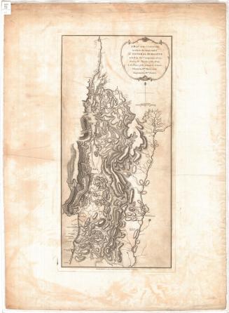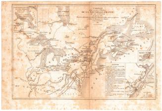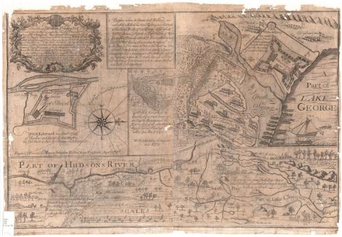
To His Excellency William Shirley, Esqr. Capt. General & Govr. in Chief in & over his Majesty's Province of ye Massachusetts Bay in New England Major General & Commander in Chief of all his Majesty's Land forces in North America. And to ye Legislators of ye Several Provinces Concerned in ye Expedition to Crown Point. This plan of Hudsons River from Albany to Fort Edward...
PrintmakerEngraved by
Thomas Johnston
(American, 1708 - 1767)
PrinterPrinted by
Thomas Johnston
(American, 1708 - 1767)
Date1756
MediumEngraving; black printer's ink on laid paper, backed with paper
DimensionsPrimary Dimensions (image height x width): 17 13/16 x 27 1/4in. (45.2 x 69.2cm)
Sheet (height x width): 18 7/8 x 27 9/16in. (47.9 x 70cm)
Mount (height x width): 19 3/8 x 27 9/16in. (49.2 x 70cm)
ClassificationsGraphics
Credit LineConnecticut Museum of Culture and History collection
Object number2012.312.78
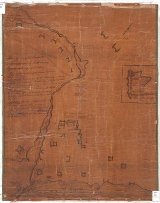
DescriptionTwo main maps, one of part of the Hudson River and the other part of Lake George. The Hudson River map is oriented east-west, with Albany City to the south and Lakes George and Champlain to the north. Various features of the river's flow are noted: notes about rocks, fast-moving or still water, and waterfalls appear on the map. The following forts are labeled and depicted with a symbol: Fort Edward, General Nicholsons' Fort, Saratoga, Fort William Henry, Ticonderoga, and Crown Point. A "carrying place" and the wagon road to Lake George are also marked.
The map depicting part of Lake George focuses on Fort William Henry and the British camps set up around it, all flying the British flag. The inscription identifies the construction materials and the diagram labels the dungeon, storehouse, guard houses, barracks and magazines. Canoes are banked on the lake, and a British ship and two manned canoes are in it. To the left, there is an inset box with notes explaining three of the four numbers found on the map: 1 identifies the spot where Colonel Ephraim Williams was killed, 2 marks the place where Colonel Titcomb was killed, and 3 identifies the army's camps, with the commanding generals' and colonels' names next to each one. Below the inset, also to the left of the map, there is a note explaining that the number 4 was the hill on which battle was waged.
Right below the cartouche, there is an inset map of Fort Edward, along the Hudson River. The inscription identifies the construction material, and the diagram labels the hospital, storehouse, magazine and barracks.
The title is contained within a decorative cartouche, featuring a leafy design with scrolls and small flowers. At the top, there is a banner with the Latin phrase "pro rege et republica," which means, "for king and state."
Label TextThe Battle of Lake George on September 8, 1755 was the first important English victory in the French and Indian War. While the English planned an attack on the French Fort Frederick at Crown Point, the French attacked the English Fort Edward, resulting in a bloody engagement on the southern shores of Lake George. While neither side obtained its objective, the English were subsequently able to construct Fort William Henry near the site of the battle, consolidating their position. Thomas Johnston's 1756 map portrays the battle somewhat schematically and seems primarily intended to celebrate the victory and the role of Johnston's home state of Massachusetts in the conflict. Johnston's lengthy text does not even allude to Major General Phineas Lyman, who led one thousand Connecticut militiamen, and who assumed command of the overall forces when Sir William Johnson (no relation to the mapmaker) was wounded and disabled during the battle. Lyman was later placed in command of Fort Edward and took part in the later battles at Crown Point and Fort Ticonderoga.
NotesCartographic Note: Scale: 1 1/2 inches equals about 5 miles; 2 1/2 inches equals about 10 rods; 2 inches equals about 30 rodsStatus
Not on view