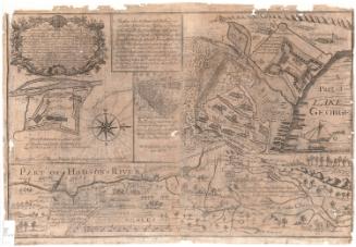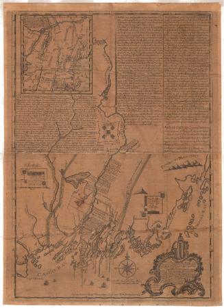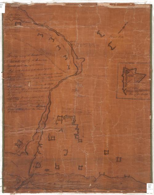
Birds eye view of the Garrison &c of Ticonderoga (by the Indian name Tigrondergua the meeting of the waters)
DraftsmanDrawn by
Unknown
Dateabout 1860
MediumDrawing; ink on paper on linen with green binding
DimensionsPrimary Dimensions (image height x width): 23 3/8 x 18 3/8in. (59.4 x 46.7cm)
Sheet (height x width): 23 5/8 x 18 7/8in. (60 x 47.9cm)
Mount (height x width): 23 5/8 x 18 7/8in. (60 x 47.9cm)
ClassificationsGraphics
Credit LineConnecticut Museum of Culture and History collection
Object number2012.312.75
DescriptionManuscript map of Fort Ticonderoga, with Lake George at the top of the map and Lake Champlain at the bottom. The north arrow points toward the top right corner. The fort's buildings and the structures and places around it are indicated with symbols, and many of them are labeled: the burial ground, a hotel, the hospital, store houses, and wells. Waterfalls and bridges along the lakes and waterways are marked, too. Unattributed quotations appear in various places that describe military actions taken by the troops on both sides.
On the verso, there is a pencil sketch of a fort.
On the verso, there is a pencil sketch of a fort.
Label TextThis manuscript map, which depicts Fort Ticonderoga and includes a lengthy text outlining its history, appears to date from the mid-nineteenth century rather than the late eighteenth century. It may be based on an earlier map, possibly an engraved book illustration. The purpose for which it was made is not known. Like other maps in the Connecticut Historical Society's collection, it may have been copied by a schoolchild as part of a history or georgraphy lesson. The name George N. Root is inscribed on the back of the map and he may have been a former owner.
NotesCartographic Note: No scaleClassification Note: In terms of this project, "historical maps" refer to those made at a later date than the time period depicted.
Status
Not on view