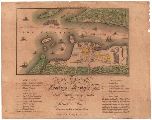
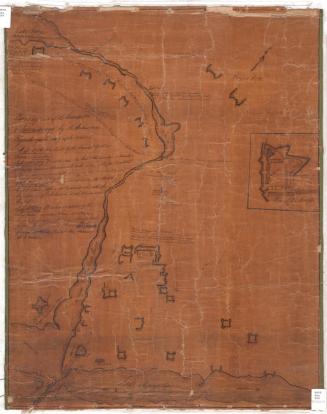
A Map of Sacketts Harbour
PublisherPublished by
Patrick May
(American, died after 1815)
Date1815
MediumEngraving; black printer's ink and watercolor on laid paper, lined with paper
DimensionsPrimary Dimensions (image height x width): 7 1/8 x 12in. (18.1 x 30.5cm)
Sheet (height x width): 12 1/2 x 15 7/8in. (31.8 x 40.3cm)
Mount (height x width): 12 1/2 x 15 7/8in. (31.8 x 40.3cm)
ClassificationsGraphics
Credit LineConnecticut Museum of Culture and History collection
Object number2012.312.74
DescriptionMap of Sacketts Harbour (now Sackets Harbor) in Jefferson County, New York, extending from Simcoe Bay to the north, the mouth of the Black River to the east, the road to Brownville to the south, and a navigable course to Lake Erie to the west. Made during the War of 1812, the map shows the Battle of Sackets Harbor, which took place on May 29, 1813. The military and naval presence is well documented: on land, there are military cantonments, or barracks; forts; and ordnance, timber and navy yards; while in Lake Ontario, military ships and gun boats patrol the waters. Named ships include the Oneida (brig), the Mohawk (ship), the Jefferson (brig), the Growler (schooner), the Zilph (brig), the Spitfire (schooner), the Superior (ship), the Madison (ship), Pike (ship), Jones (brig), and the Lady of the Lake (schooner). A marine hospital, the public square, various stores, the brewery, the burying ground, and other notable places are labeled. Small symbols mark various dwelling places, including boarding houses; eating houses; taverns; printing offices; places of execution; sheds; block houses; and the location of the provost guard.Two inscriptions mark the fall of General Gray and the place where the dead enemy forces were buried.
Label TextThis map of Sackett's Harbor, New York, which served as an important staging ground for the invasion of Canada during the War of 1812, was published in Bristol, Connecticut in 1815. It is based on a drawing by Patrick May, an officer from Mississippi, who was stationed at the large military base there.
NotesCartographic Note: No ScaleStatus
Not on view
Kenneth J. Winschel
April 1952