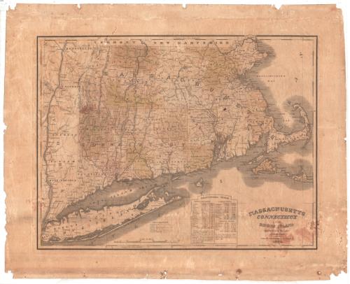
Massachusetts, Connecticut and Rhode Island Constructed from the Latest Authorities
PublisherPublished by
H. F. Sumner & Co.
(American, active 1832 - 1848)
Date1833
MediumEngraving; black printer's ink and watercolor on wove paper
DimensionsPrimary Dimensions (image height x width): 15 1/8 x 19 5/8in. (38.4 x 49.8cm)
Platemark (height x width): 15 3/4 x 20 3/8in. (40 x 51.8cm)
Sheet (height x width): 19 3/8 x 24in. (49.2 x 61cm)
Platemark (height x width): 15 3/4 x 20 3/8in. (40 x 51.8cm)
Sheet (height x width): 19 3/8 x 24in. (49.2 x 61cm)
ClassificationsGraphics
Credit LineConnecticut Museum of Culture and History collection
DescriptionMap of the states of Massachusetts, Connecticut and Rhode Island, from the borders of Vermont and New Hampshire to the north, Massachusetts Bay to the east, Long Island and the Atlantic Ocean to the south, and the Hudson River to the west. State boundaries are delineated with broken solid lines, counties with broken solid lines, and towns by dotted lines. Cities and settlements are indicated with circles and are labeled. The map emphasizes transportation, with main and common roads, existing and proposed canals, and existing and proposed railroads all depicted using different types of lines. Below the map is a statistical table listing the counties of the three states and their population numbers in 1820 and 1830. Elevation is conveyed through hachure marks.
Object number2012.312.67
NotesCartographic Note: Scale: 4 1/2 inches equals 50 milesOn View
Not on view


Lucius Stebbins & Co.
1859