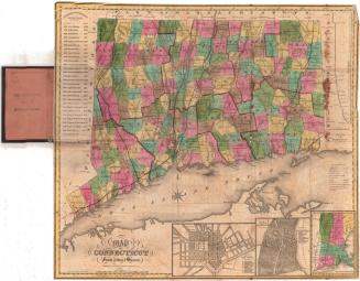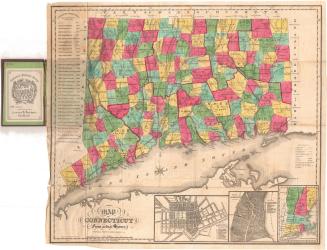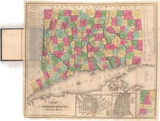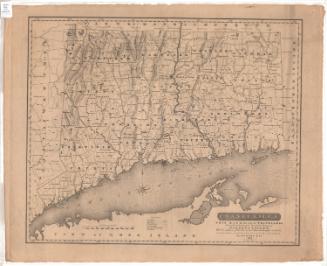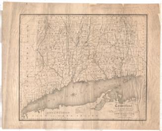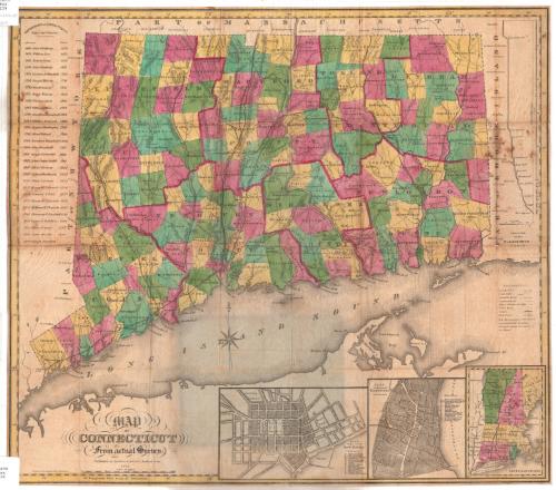
Map of Connecticut from actual survey
PrintmakerEngraved by
Daggett & Ely
(American, 1831 - 1836)
PublisherPublished by
Brown and Parsons
(American, 1838 - 1851)
Date1849
MediumEngraving; black printer's ink and watercolor on wove paper, unfolded from cardboard covers
DimensionsPrimary Dimensions (image height x width): 19 1/8 x 21 1/2in. (48.6 x 54.6cm)
Sheet (height x width): 19 1/4 x 21 5/8in. (48.9 x 54.9cm)
ClassificationsGraphics
Credit LineConnecticut Museum of Culture and History collection
Object number2012.312.65
DescriptionMap of Connecticut, with Massachusetts to the north, Rhode Island to the east, the Long Island Sound to the south, and New York to the west. All of the towns in the state are bounded by solid black lines, and are colored blue, yellow, green or pink, and the counties are bounded by broken solid and dotted lines that are colored dark pink. Turnpikes, "common" roads, places of public worship, courthouses, canals and railroads are depicted on the map with lines and symbols. Four vignettes, one to the right of the map and three below it, show a "Profile of the Farmington Canal," plans of New Haven and Hartford, and the New England states, respectively. To the left of the map is a list of the governors of Connecticut since the charter. The map was originally folded into covers with the title "Map of Connecticut," the cardboard covers are attached to the verso of the encapsulation.
Label TextThe Hartford publisher Brown & Parsons took over Daggett & Ely's engraved map of Connecticut from its original publisher, Eleazer Huntington. Huntington first published the map in 1836, including the list of Connecticut Governors, the inset maps of Hartford and New Haven, and the profile of the Farmington Canal. When they republished the map in the 1840s, Brown & Parsons updated the list of Governors and updated the map to show new towns that had been incorporated since earlier editions, but they did not remove the profile of the Farmington Canal, and the canal itself still appears on the map, even though by 1849, when this edition of the map was published, the canal had largely been replaced by a railroad that utilized the former towpath as its roadbed.
The bright coloring of this map is typical of the maps (and prints) that were being producted in Hartford, Connecticut during the 1840s. The coloring is watercolor and was applied by hand by a bevy of women colorists employed by the map's printer, each woman being responsible for one color. Stencils were used to assure neatness and consistency in coloring.
NotesCartographic Note: Scale: About 7/8" equals 5 milesThe bright coloring of this map is typical of the maps (and prints) that were being producted in Hartford, Connecticut during the 1840s. The coloring is watercolor and was applied by hand by a bevy of women colorists employed by the map's printer, each woman being responsible for one color. Stencils were used to assure neatness and consistency in coloring.
Constituent Note: Even though the firm of Daggett & Ely was long defunct by the time this edition of their map was published, their original plate still survived and continued to be updated and resissued.
Status
Not on view