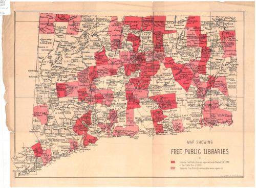
Map showing free public libraries
PublisherPublished by
Geo. H. Walker & Co.
(American, founded 1880)
Date1896
MediumLithography; black and red printer's ink on wove paper
DimensionsPrimary Dimensions (image height x width): 10 3/4 x 14 7/8in. (27.3 x 37.8cm)
Sheet (height x width): 12 x 16 1/4in. (30.5 x 41.3cm)
Sheet (height x width): 12 x 16 1/4in. (30.5 x 41.3cm)
ClassificationsGraphics
Credit LineConnecticut Museum of Culture and History collection
DescriptionMap of Connecticut, divided into towns and counties, showing the towns in which free public libraries exist that were organized under Chapter CLXXVIII of the Public Acts of 1893, indicated by solid red shading; and the towns in which free public libraries exist that were otherwise created, indicated by red and white striped shading. Villages and cities in the towns are denoted with circles and names. The New York, New Haven and Hartford; New England; Vermont; Reading; and the Northeast Division Railroads are labeled. Other railroad lines are delineated, but their names are not provided. The bordering states' names and that of the Long Island Sound do not appear on the map.
Object number2012.312.63
NotesCartographic Note: No ScaleOn View
Not on view


Haris Gusta Guya
2011 November 4