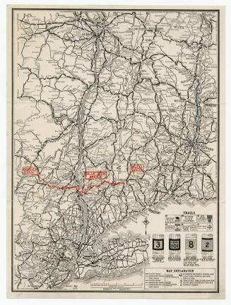
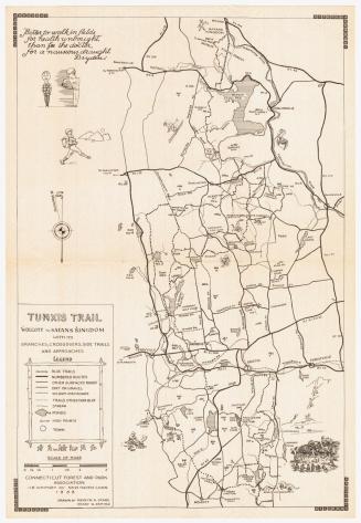
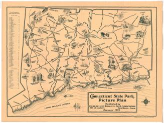
Appalachian Trail: The Connecticut Trail System
PublisherPublished by
Connecticut Forest and Park Association
(American, founded 1895)
DraftsmanDrawn by
Ralph A. Wheeler
(American, 1893 - 1984)
Date1934
MediumLithography; black printer's ink on wove paper
DimensionsPrimary Dimensions (image height x width): 27 x 13 1/4in. (68.6 x 33.7cm)
Sheet (height x width): 28 1/8 x 14 1/4in. (71.4 x 36.2cm)
ClassificationsGraphics
Credit LineConnecticut Museum of Culture and History collection
Object number2012.312.52
DescriptionTrail map of the Appalachian and the Mattatuck Trails as they run through Connecticut, from Indian Rocks at the border of New York to Bear Mountain at the border of Massachusetts. Along the routes are circled numbers that mark trail or road junctions, as well as circled "S"es that denote the locations of springs. Other, smaller trails are also included and labeled, as are mountains and their height in feet. The Berkshire Division of the New York, New Haven and Hartford Railroad runs north-south across the map, and the Southern New England Railroad runs east-west.
Label TextThe idea for the Appalachian Trail, a long-distance hiking trail running from Maine to Georgia, originated in 1922. The Connecticut Forest and Park Association embraced the plan with enthusiasm, and the Connecticut portion of the trail through the scenic northwest part of the state was one of the first to be completed. Ned Anderson, a farmer living in Sherman, Connecticut, was responsible for mapping and blazing this portion of the trail between 1929 and 1933. This map, issued in 1934, shows the trail immediately after it was first completed.
NotesCartographic Note: Scale: 1 inch equals 1 mileStatus
Not on view