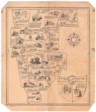
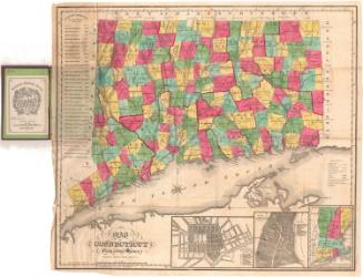
Historical Map of New London County, 1666-1933
DraftsmanDrawn by
S. Jerome Hoxie
(American, 1895 - 1981)
PublisherPublished by
League of Women Voters (New London County, Conn.)
(American, founded after1920)
Date1934
MediumLithography; black printer's ink on paper, mounted on mat board
DimensionsPrimary Dimensions (image height x width): 15 3/8 x 18 1/4in. (39.1 x 46.4cm)
Sheet (height x width): 16 3/8 x 19 5/8in. (41.6 x 49.8cm)
Mount (height x width): 16 3/8 x 19 5/8in. (41.6 x 49.8cm)
ClassificationsGraphics
Credit LineConnecticut Museum of Culture and History collection
Object number2012.312.51
DescriptionPictorial map of New London County, Connecticut, with the names of its towns, their dates of settlement and incorporation, and small drawings of notable landmarks or events. The cartouche contains the city of New London's seal, depicting a three-masted ship, sails unfurled, with a banner above it with the Latin phrase, "Mare liberum," or "The freedom of the sea." To the left is an eight-point compass rose. The map is bordered on the right and left sides with a series of small drawings, presumably related to New London's history: a stalk of corn, a leaf, a bow, an arrowhead, a candle, a book, and more.
Label TextOne of the goals of the League of Women Voters is to promote the political education of the public at large in order to create informed citizens and voters. Understanding local history can not only be a means of fostering local pride; it can also contribute to a broader understanding of American democracy. The League of Women Voters also published similar maps of other Connecticut Counties, suggesting that this was a statewide initiative.
NotesCartographic Note: No scaleStatus
Not on view