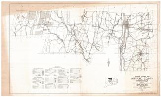
Tunxis Trail
DraftsmanDrawn by
Romeyn A. Spare
(American, 1885 - 1968)
DraftsmanDrawn by
Perry N. Deming
(American, 1888 - 1962)
PublisherPublished by
Connecticut Forest and Park Association
(American, founded 1895)
Date1955
MediumLithography; black printer's ink on wove paper
DimensionsPrimary Dimensions (image height x width): 18 x 12in. (45.7 x 30.5cm)
Sheet (height x width): 18 3/4 x 12 7/8in. (47.6 x 32.7cm)
ClassificationsGraphics
Credit LineConnecticut Museum of Culture and History collection
Object number2012.312.50
DescriptionMap of the Tunxis Trail in Connecticut, with Satans Kingdom to the north, Unionville to the east, Wolcott to the south, and Route 72 to the west. The legend, located in the bottom left corner, contains an explanation of the various lines and symbols found on the map. Not mentioned in the legend are the little pictures that appear on the map, many of them of people engaged in outdoor pursuits such as swimming, camping, rock climbing, and skiing, and also of a dinosaur two Native Americans in traditional dress, and the devil with a pitchfork. The New York, New Haven and Hartford Railroad runs east-west across the map. At the top left corner is a quote from Dryden: "Better to walk in fields / for health unbrought, / than fee the doctor, / for a nauseous draught" below which is a drawing of a doctor doling out medicine on a spoon to a main in a plaid shirt.
Label TextThis map shows the Tunxis Trail, a 79-mile long hiking trail, that is part of Connecticut's blue-blazed hiking trail system, as it existed in 1955. Much of the trail runs through private lands and part of the route has been altered in the course of the intervening years but the trail remains popular with hikers. The two men who drew this 1955 map were both local residents; Romeyn A. Spare lived in Bristol and Perry N. Deming lived in Burlington, both towns that lie along the trail's route. Connecticut's blue-blazed hiking trail system was established in 1929 by the Connecticut Forest and Park Association. The trail system expanded during the 1930s using unemployed labor from the Civilian Conservation Corps and similar state work projects.
NotesCartographic Note: Scale: 1 inch equals 1 mileStatus
Not on view