Granger Mills on the Connecticut River
DraftsmanDrawn by
Unknown
Date1794
MediumDrawing; black ink and watercolor on laid paper
DimensionsPrimary Dimensions (image .a height x width): 15 1/4 x 5 3/4in. (38.7 x 14.6cm)
Primary Dimensions (image .b height x width): 6 3/8 x 15 5/8in. (16.2 x 39.7cm)
Sheet (height x width): 15 5/8 x 13in. (39.7 x 33cm)
Mount (height x width): 15 7/8 x 13 1/8in. (40.3 x 33.3cm)
Primary Dimensions (image .b height x width): 6 3/8 x 15 5/8in. (16.2 x 39.7cm)
Sheet (height x width): 15 5/8 x 13in. (39.7 x 33cm)
Mount (height x width): 15 7/8 x 13 1/8in. (40.3 x 33.3cm)
ClassificationsGraphics
Credit LineConnecticut Museum of Culture and History collection
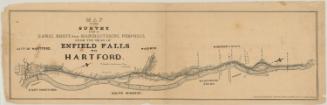
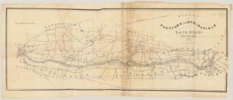
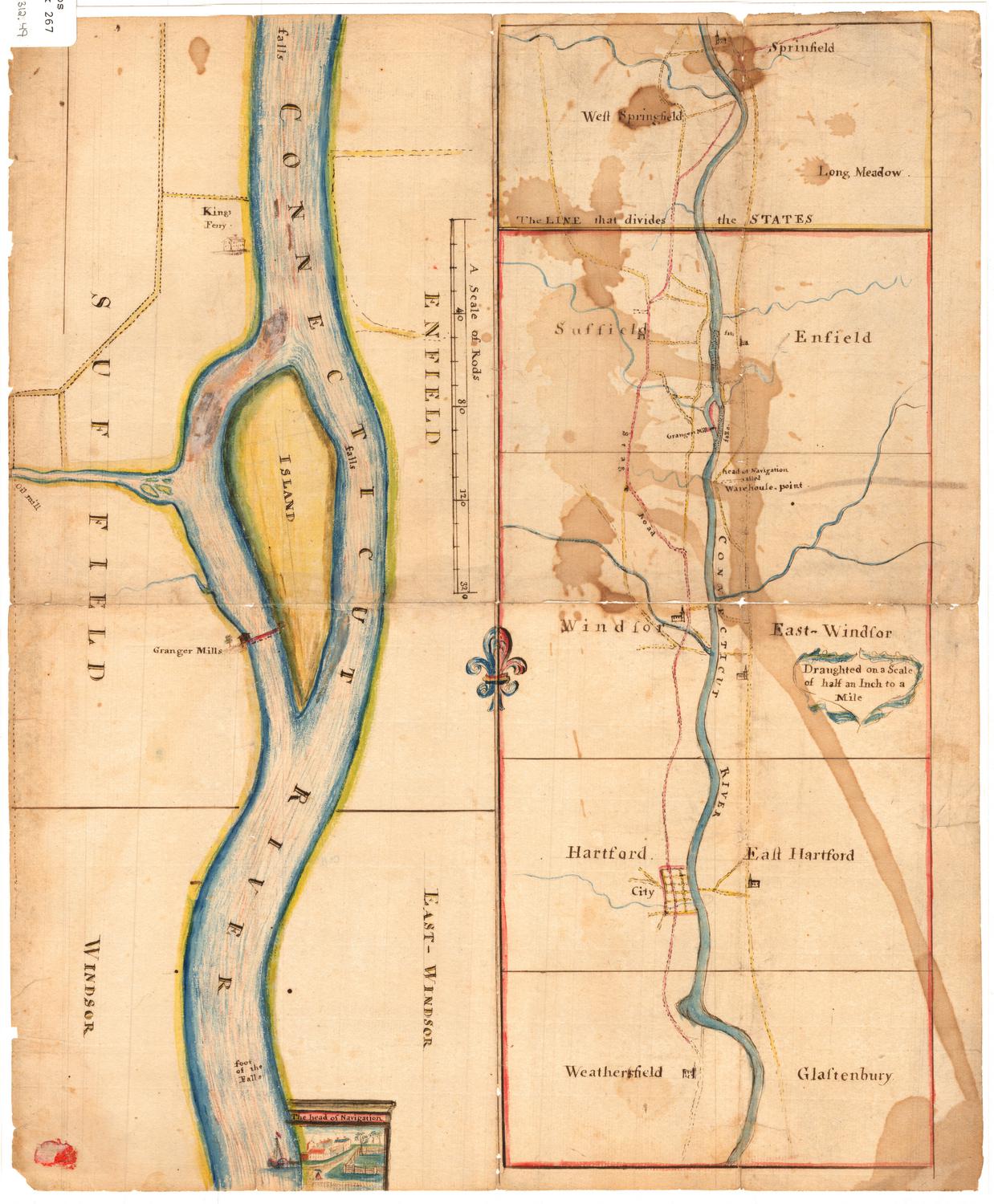
DescriptionTwo manuscript maps side-by-side with a small fleur de lis, half red and half blue, connecting them. On the right, or top, is a map of the Connecticut River from Springfield, Massachusetts, to Glastonbury, Connecticut, divided into five boxed sections. The Massachusetts portion is outlined in yellow, while the Connecticut portion is outlined in red. The following towns are labeled: Springfield, West Springfield, and Long Meadow, Massachusetts; and Suffield, Enfield, Windsor, East Windsor, Hartford, East Hartford, "Weathersfield," and "Glastenbury," Connecticut. Church buildings are drawn but not labeled, and the only labeled road is Stag Road. Granger Mills between Suffield and Enfield, and Warehouse Point in East Windsor are found along the river.
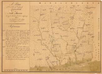
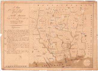
The map on the left, or bottom, is a closer view of the Connecticut River in Enfield, Suffield, Windsor and East Windsor. The locations of several waterfalls are marked along the river. Kings Ferry in Suffield is labeled, next to a drawing of a building, and further south along the river, Granger Mills' building and what appears to be a bridge to an island in the center of the river are depicted. The "head of Navigation" is also included, with a drawing of what appears to be a paddle steamer, and a scene depicting a small group of buildings and a fenced-in lot with trees.
The map on the left, or bottom, is a closer view of the Connecticut River in Enfield, Suffield, Windsor and East Windsor. The locations of several waterfalls are marked along the river. Kings Ferry in Suffield is labeled, next to a drawing of a building, and further south along the river, Granger Mills' building and what appears to be a bridge to an island in the center of the river are depicted. The "head of Navigation" is also included, with a drawing of what appears to be a paddle steamer, and a scene depicting a small group of buildings and a fenced-in lot with trees.
Object number2012.312.49
NotesCartographic Note: Scale [ca. 1:126,720]. Half an inch to a mile.
On View
Not on view