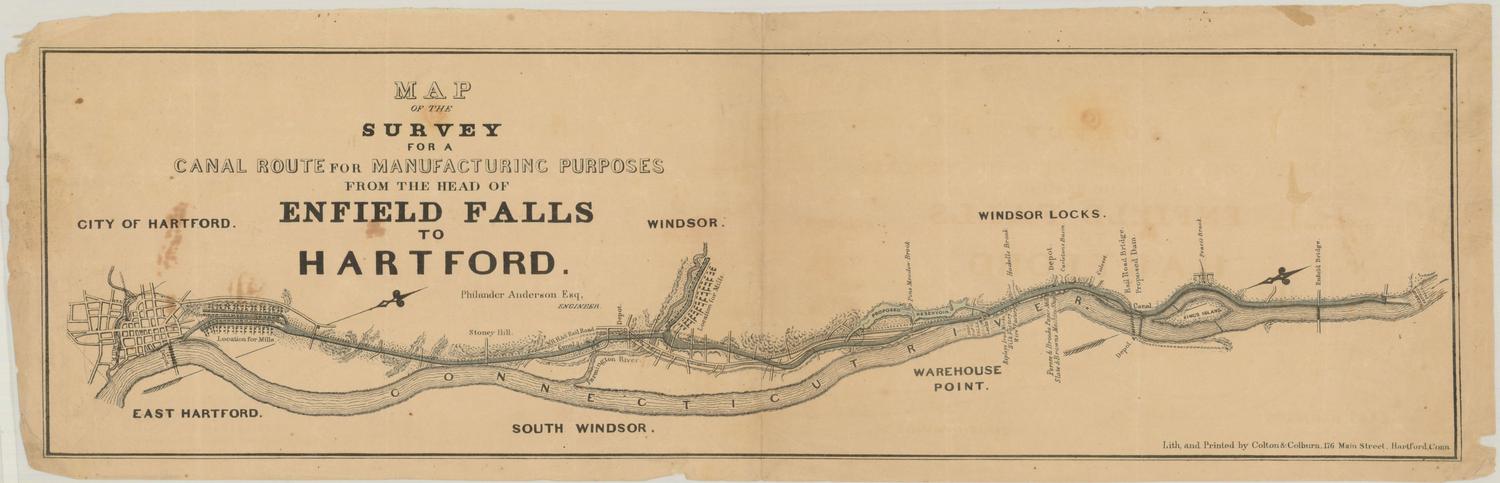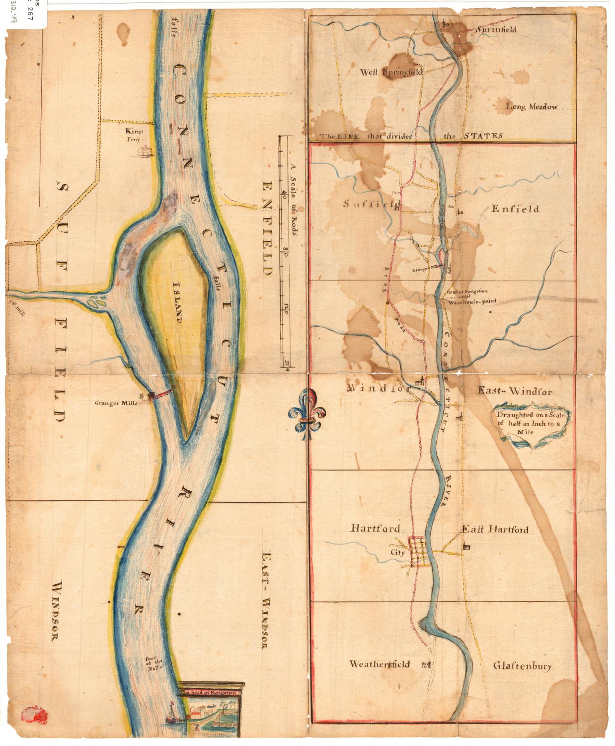
Granger Mills on the Connecticut River
DraftsmanDrawn by
Unknown
Date1794
MediumDrawing; black ink and watercolor on laid paper
DimensionsPrimary Dimensions (image .a height x width): 15 1/4 x 5 3/4in. (38.7 x 14.6cm)
Primary Dimensions (image .b height x width): 6 3/8 x 15 5/8in. (16.2 x 39.7cm)
Sheet (height x width): 15 5/8 x 13in. (39.7 x 33cm)
Mount (height x width): 15 7/8 x 13 1/8in. (40.3 x 33.3cm)
ClassificationsGraphics
Credit LineConnecticut Museum of Culture and History collection
Object number2012.312.49
DescriptionTwo manuscript maps side-by-side with a small fleur de lis, half red and half blue, connecting them. On the right, or top, is a map of the Connecticut River from Springfield, Massachusetts, to Glastonbury, Connecticut, divided into five boxed sections. The Massachusetts portion is outlined in yellow, while the Connecticut portion is outlined in red. The following towns are labeled: Springfield, West Springfield, and Long Meadow, Massachusetts; and Suffield, Enfield, Windsor, East Windsor, Hartford, East Hartford, "Weathersfield," and "Glastenbury," Connecticut. Church buildings are drawn but not labeled, and the only labeled road is Stag Road. Granger Mills between Suffield and Enfield, and Warehouse Point in East Windsor are found along the river.
The map on the left, or bottom, is a closer view of the Connecticut River in Enfield, Suffield, Windsor and East Windsor. The locations of several waterfalls are marked along the river. Kings Ferry in Suffield is labeled, next to a drawing of a building, and further south along the river, Granger Mills' building and what appears to be a bridge to an island in the center of the river are depicted. The "head of Navigation" is also included, with a drawing of what appears to be a paddle steamer, and a scene depicting a small group of buildings and a fenced-in lot with trees.
The map on the left, or bottom, is a closer view of the Connecticut River in Enfield, Suffield, Windsor and East Windsor. The locations of several waterfalls are marked along the river. Kings Ferry in Suffield is labeled, next to a drawing of a building, and further south along the river, Granger Mills' building and what appears to be a bridge to an island in the center of the river are depicted. The "head of Navigation" is also included, with a drawing of what appears to be a paddle steamer, and a scene depicting a small group of buildings and a fenced-in lot with trees.
Label TextThe island that figures so prominently in this map of the Connecticut River is King Island, located between Suffield and Enfield, Connecticut. King Island, which belonged to the King family of Suffield, is the largest island in the Connecticut River. In the nineteenth century, it was largely cultivated, though subsequently the land reverted to forest. The King family also operated King's ferry, just upstream from the island. Granger Mills, located just downstream from the island, belonged to another prominent Suffield family. This stretch of river was located above the head of navigation, and falls and rapids made it difficult to cross the river safely. Zadock and Elijah Granger were among the citizens of Suffield who petititoned the State Legislature to build a bridge across the river in the 1790s. A toll bridge was finally built about 1810; subsequently the Enfield Canal (completed in 1829) and the railroad would facilitate transportion in the area.
NotesCartographic Note: Scale [ca. 1:126,720]. Half an inch to a mile.Status
Not on view