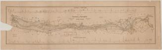
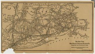
Survey of Hartford and Springfield Rail Road
SurveyorSurveyed by
James N. Palmer
(American, about 1803 - 1866)
DraftsmanDrawn by
Charles Buck
(1817 - 1845)
PrinterPrinted by
E.B. & E.C. Kellogg
(American, 1840 - 1867)
Date1841
MediumLithography; black printer's ink on wove paper
DimensionsPrimary Dimensions (image height x width): 10 3/8 x 28in. (26.4 x 71.1cm)
Sheet (height x width): 12 x 29 1/4in. (30.5 x 74.3cm)
ClassificationsGraphics
Credit LineConnecticut Museum of Culture and History collection
Object number2012.312.48
DescriptionMap from Hartford, Connecticut, to Springfield, Massachusetts, oriented east-west on the map, with Hartford on the left, Springfield on the right, and the Connecticut River on the bottom. The towns between the two cities are labeled, and what are presumably roads are denoted with parallel solid lines but are not labeled. The potential railroad routes are depicted with solid single lines. There are various routes running between Hartford and Springfield; at least two are identified as the Hartford and New Haven Railroad and the Western Railroad, while the others are unlabeled. Other notable landmarks include Kings Island and the Farmington, Scantic, Mill and Fresh Water Rivers. The magnetic north arrow at the top of the map points toward the top right corner.
Label TextThis survey of the Hartford and Springfield Rail Road was folded and bound into the Report of the Engineer upon the Several Definite Locations for the Hartford and Springfield Rail Road, published in 1841. In his report, Chief Engineer James N. Palmer described several possible routes on both the east and west banks of the Connecticut River, the advantages and disadvantages of each of route, and the estimated cost involved. The line opened for service in December 1844 along a combined east and west route, crossing the river a little below King Island.
NotesCartographic Note: Scale: 1 inch equals 5000 feetStatus
Not on view
Rand Avery Supply Co.
about 1900