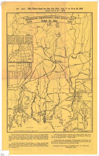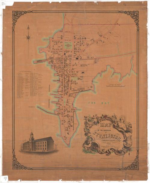
Map of the Borough of Stonington, Connecticut
SurveyorSurveyed by
John Bevan
(American, born about 1820)
SurveyorSurveyed by
John F. Harrison
(American, born about 1820)
PrinterPrinted by
Sarony & Major
(American)
PublisherPublished by
John Bevan
(American, born about 1820)
Date1851
MediumLithography; black printer's ink and watercolor on wove paper, lined with linen
DimensionsPrimary Dimensions (image height x width): 20 x 20 7/8in. (50.8 x 53cm)
Sheet (height x width): 29 x 23 7/8in. (73.7 x 60.6cm)
Mount (height x width): 29 x 23 7/8in. (73.7 x 60.6cm)
Sheet (height x width): 29 x 23 7/8in. (73.7 x 60.6cm)
Mount (height x width): 29 x 23 7/8in. (73.7 x 60.6cm)
ClassificationsGraphics
Credit LineConnecticut Museum of Culture and History collection
DescriptionMap of Stonington, Connecticut, from the borough boundary to the north, Samuel Chesebro's land to the east, Stonington Point to the south, and Stonington Harbor to the west. Borough streets are labeled, and buildings are depicted, sometimes with the owner or occupant's name. The map contains numbers from 1-63 that correspond to an enumerated list of subscribers by name, located to the left of the map. Some occupations are also listed. Below the map is a vignette of John F. Trumbull's factory. The cartouche is decorated with the figure of a woman wearing a liberty cap and holding the American flag, and a man, possibly Bacchus, wearing a crown of what appear to be olive leaves, crading a jug of liquid.
Object number2012.312.42
NotesCartographic Note: No scale
Subject Note: The factory building that figures so prominently on this map was destroyed by fire on 3 July 2003.
On View
Not on view