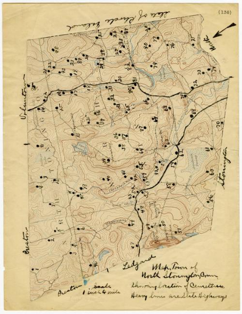
Map, Town of North Stonington, Connecticut
SurveyorSurveyed by
Geological Survey (U.S.)
(American, founded 1879)
PublisherPublished by
Geological Survey (U.S.)
(American, founded 1879)
MakerAnnotated by
Unknown
Dateafter 1895
MediumLithography; black, blue and brown printer's ink on paper, on paper with notes in black ink
DimensionsPrimary Dimensions (image height x width): 7 1/4 x 10 1/4in. (18.4 x 26cm)
Sheet (height x width): 11 x 8 1/2in. (27.9 x 21.6cm)
ClassificationsGraphics
Credit LineConnecticut Museum of Culture and History collection
Object number2012.312.40
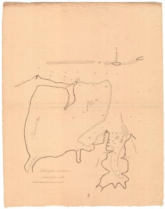
DescriptionTopographical map of North Stonington, pasted on a piece of paper with handwritten inscriptions. It is bordered to the north by Preston and Voluntown, to the east by Rhode Island, the south by Stonington, and the west by Preston and Ledyard. Handwritten numbers on the map probably indicate the locations of cemeteries. The north arrow, in the top right corner, points toward the lower left corner of the map.
Label TextSomeone neatly cut the town of North Stonington out of a geodetic survey map and annotated it with locations of over ninety cemeteries, most of them small family burial grounds, and the routes of two state highways. Probably the work of a local historian or genealogist, the map must date from after 1895 when the Connecticut State Highway Commission was created. Since the roads are not numbered, it probably dates from before 1926 when the current system of numbering highways was introduced. This map neatly demonstrates the re-use of a published map for a personal purpose.
NotesCartographic Note: Scale: "1 inch to mile"Status
Not on view