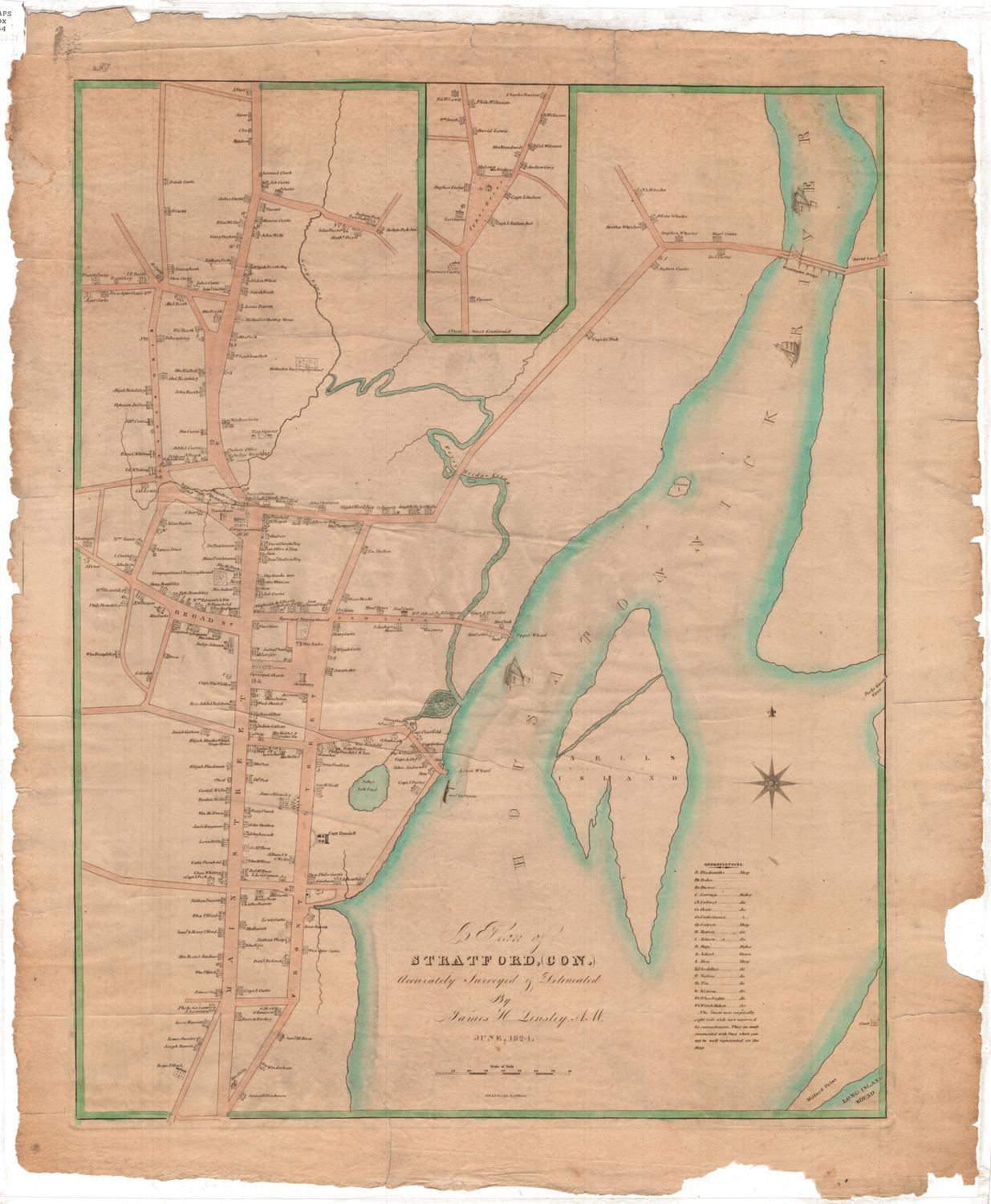
A Plan of Stratford, Connecticut
SurveyorSurveyed by
James Harvey Linsley
(American, 1787 - 1843)
DraftsmanDrawn by
James Harvey Linsley
(American, 1787 - 1843)
PrintmakerEngraved by
N. & S. S. Jocelyn
(American, founded 1818)
Date1824
MediumEngraving; printer's ink and watercolor on wove paper
DimensionsPrimary Dimensions (image height x width): 22 1/4 x 17 1/2in. (56.5 x 44.5cm)
Platemark (height x width): 23 3/8 x 17 7/8in. (59.4 x 45.4cm)
Sheet (height x width): 25 x 21in. (63.5 x 53.3cm)
ClassificationsGraphics
Credit LineConnecticut Museum of Culture and History collection
Object number2012.312.38
DescriptionMap of Stratford, Connecticut, extending from J. Frost's residence to the north, the Housatonic River to the east, James Blackman's residence to the south, and King Street to the west. Residences, churches and businesses are depicted, with the names of the owners inscribed next to the representation. In the Housatonic River (spelled "Housatonnick" on the map), there are several named ships: Wm., Tolerance, and Mary. Crossing the river at the top right is the Washington Bridge. In the bottom right corner, Milford Point crosses the Long Island Sound. Ferry Bridge Creek, Long Brook and Selby's Salt Pond are the other bodies of water named on the map.
Label TextStratford, first settled in 1639, originally included the land that became the towns of Shelton, Monroe, Trumbull, and part of Bridgeport. The latest of these subdivisions took place in 1821, when the town of Bridgeport was incorporated over the protests of its inhabitants. Stratford, the parent town, was in favor of the separation, fearing that the original settlement would be overshadowed by Bridgeport's rapid growth. This map, issued three years later, appears to be an expression of the civic pride of the citizens of Stratford. James Harvey Linsley, who surveyed and drew the map, had moved to Stratford in 1821 to open a boarding school for boys.
NotesCartographic Note: Scale: 3/8" equals about 10 rodsStatus
Not on view