
Connecticut From the best Authorities
PrinterPrinted by
Meriden Gravure Company
(American, 1888 - 1977)
After a work byAfter a work by
Amos Doolittle
(American, 1754 - 1832)
Date1957
MediumPhotomechanical reproduction; black ink on wove paper
DimensionsPrimary Dimensions (image height x width): 12 1/4 x 15 1/8in. (31.1 x 38.4cm)
Sheet (height x width): 15 1/4 x 19in. (38.7 x 48.3cm)
ClassificationsGraphics
Credit LineConnecticut Museum of Culture and History collection
Object number2012.312.36
DescriptionReproduction of Amos Doolittle's map of Connecticut, with the borders of Vermont and Massachusetts to the north, Rhode Island to the east, part of Long Island and the Long Island Sound to the south, and New York to the west. Counties and towns are shown, as well as courthouses and churches. Elevation is depicted with clusters of peaks. The cartouche is decorative, with the state seal and motto lying next to a tree on the shoreline.
Label TextThe Meriden Gravure Company of Meriden, Connecticut, did good quality printing for museums and libraries and was known for its fine reproductions of works of art. This reproduction is based on a map by the New Haven engraver Amos Doolittle, which originally appeared in an edition of William Guthrie's New System of Modern Geography published in Philadelphia by Mathew Carey in 1795. A copy of the original map is also in the collections of the Connecticut Historical Society. This reproduction was acquired as an example of twentieth-century fine printing by an important Connecticut firm.
NotesCartographical Note: Scale on the original map: About 3/4 inch equals about 6 milesStatus
Not on view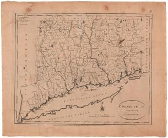


Joel Knott Allen
1791 or 1792


Lucius Stebbins & Co.
1859
