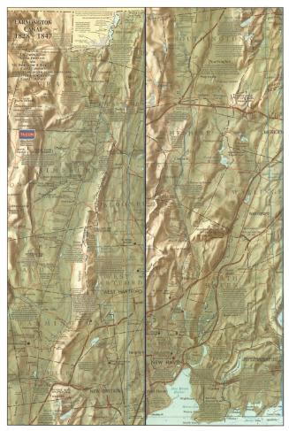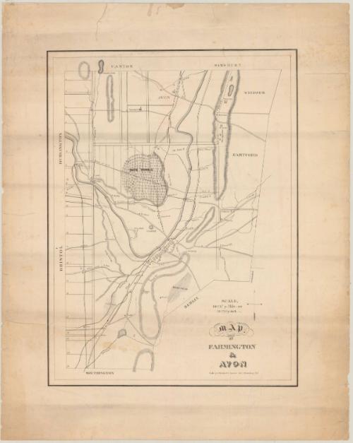
Map of Farmington & Avon
PrinterPrinted by
Stodart & Currier
(1834 - 1835)
Date1835
MediumLithography; black printer's ink on wove paper
DimensionsPrimary Dimensions (image height x width): 18 3/8 x 13 3/4in. (46.7 x 34.9cm)
Sheet (height x width): 23 7/8 x 19 1/8in. (60.6 x 48.6cm)
Sheet (height x width): 23 7/8 x 19 1/8in. (60.6 x 48.6cm)
ClassificationsGraphics
Credit LineConnecticut Museum of Culture and History collection
DescriptionMap of Farmington and Avon, Connecticut, extending from the town lines of Canton and Simsbury to the north, Windsor and Hartford to the east, Southington and Berlin to the south, and Bristol and Burlington to the west. Woods, swamps, banks and rivers are delineated and labeled, and elevation is conveyed with hachure marks. On the left side, the map has been divided into 21 numbered rows, for which no explanation is provided. Around the area called "Pine Woods," there are nine lines dividing that section into unnumbered columns, and again, there is no explanation. Roads are marked but not labeled. The Farmington Canal (labeled "Canal") runs from lower left to upper center, with a separate "Feeder" serving Unionville (called "Union' on the map). The location of the Farmington Aqueduct is indicated. Dwellings are marked but the ones in what is the center of town in Farmington are not labeled, while many of the landmarks, including churches, farms and houses, on the outskirts of town are identified with a name.
Object number2012.312.35
NotesCartographic Note: Scale: 1 inch equals 50 chains; 120 chains = 1 mile
Constituent Note: The Currier who was a partner in the firm of Stodart & Currier which printed this map is the same Nathaniel Currier who later became a partner of James Merritt Ives. Currier & Ives (1857-1907) were the most famous American lithographers of the nineteenth century.On View
Not on view