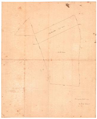
A Plan of a Piece of Land Belonging to Captain David Grant...
SurveyorSurveyed by
James Newberry
(American, 1778 - 1866)
Datebefore 1842
MediumDrawing; black ink on wove paper
DimensionsPrimary Dimensions (image height x width): 7 x 7 3/4in. (17.8 x 19.7cm)
Sheet (height x width): 10 1/4 x 16 1/4in. (26 x 41.3cm)
ClassificationsGraphics
Credit LineConnecticut Museum of Culture and History collection
Object number2012.312.32
DescriptionMap of a land lot outlined with a solid line, with coordinates given for each side and measurements in acres, what appears to be links, and rods. The lot is divided into three sections, divided by dotted lines and with measurements included.
Label TextIt appears likely that the Captain David Grant who owned this piece of land lived in Bloomfield and that the land in question was located on Talcott Mountain. David Grant of Bloomfield was born about 1770 and died in 1842. That made him a close contemporary of Daniel Wadsworth (1771-1848), the Hartford philanthropist and the founder of the Wadsworth Atheneum, who also owned land on Talcott Mountain. The fact that Grant's son was named David Wadsworth Grant suggests a possible connection between the two families.
NotesCartographic Note: No scaleStatus
Not on view