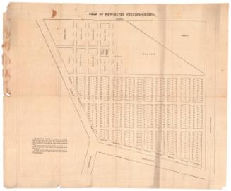
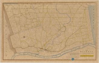
Plan of the Village of Litchfield Ct. and Vicinity
MakerCompiled by
George Catlin Woodruff
(American, 1805 - 1888)
PrinterPrinted by
George Hayward
(Anglo-American, 1800 - 1872)
Date1845
MediumLithography; black printer's ink on wove paper
DimensionsPrimary Dimensions (image height x width): 12 1/8 x 15 3/8in. (30.8 x 39.1cm)
Sheet (height x width): 13 1/4 x 16 3/8in. (33.7 x 41.6cm)
ClassificationsGraphics
Credit LineConnecticut Museum of Culture and History collection
Object number2012.312.30
DescriptionStreet map of Litchfield, Connecticut extending from North Street to the north, Chestnut Hill Street to the east, the Bantam River to the south, and North West Street to the west. Plots of land on each street are identified by the name of the owner and the by number in the order in which they were chosen, and some of them include their size in rods.
Label TextGeorge C. Woodruff, a lawyer and antiquarian in Litchfield, Connecticut, did much to arouse the interest of his fellow citizens in the history of their town. Long before Americans in general began to focus on their Colonial heritage, Woodruff began doing research on the Colonial period and encouraging others to take an active interest as well. In 1845, he published his History of the Town of Litchfield and presented a copy to the Connecticut Historical Society. For his map, he compiled information from town records, including original deeds and surveys.
Woodruff's map shows the lots of Litchfield's original eighteenth-century settlers laid out along a grid of streets that can, with some difficulty, be reconciled with the modern street plan. Ironically, Litchfield's town green is nowhere in evidence. The current town green is a creation of the early twentieth century Colonial Revival, when the town sought to recreate itself as an ideal New England village.
NotesCartographic Note: No scaleWoodruff's map shows the lots of Litchfield's original eighteenth-century settlers laid out along a grid of streets that can, with some difficulty, be reconciled with the modern street plan. Ironically, Litchfield's town green is nowhere in evidence. The current town green is a creation of the early twentieth century Colonial Revival, when the town sought to recreate itself as an ideal New England village.
Status
Not on view


Erastus Worthington
1907