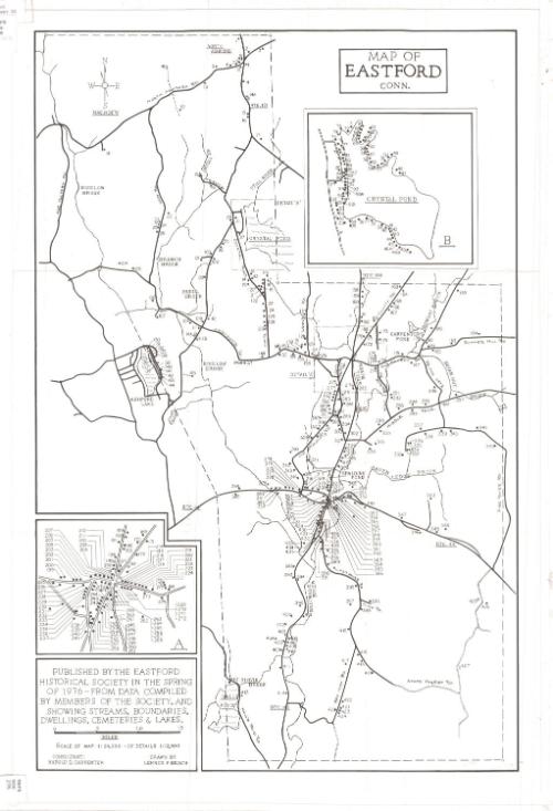
Map of Eastford, Connecticut
DraftsmanDrawn by
Lennox F. Beach
(American, 1903 - 1995)
MakerAssisted by
Harold D. Carpenter
(American, 1904 - 1977)
PublisherPublished by
Eastford Historical Society
(American, founded 1966)
Date1976
MediumLithography; black printer's ink on wove paper
DimensionsPrimary Dimensions (image height x width): 23 3/4 x 15 1/2in. (60.3 x 39.4cm)
Sheet (height x width): 25 x 17in. (63.5 x 43.2cm)
Sheet (height x width): 25 x 17in. (63.5 x 43.2cm)
ClassificationsGraphics
Credit LineConnecticut Museum of Culture and History collection
DescriptionMap of Eastford, Connecticut, from North Ashford to the north, Fire Tower Road to the east, Hall's Pond to the south, and Axe Factory Road to the west. Numbers presumably corresponding to land lots are marked on the map, and natural features such as rivers, ponds and brooks are labeled. Names include Bungay Brook, Indian Hut Brook, and Slovik Brook. At the bottom left, there is an inset map, labeled "A," of the houses in the area where Route 157A, County Road and Route 198 intersect. At the top right there is an inset map, labeled "B," of Crystal Pond and the residences that surround it.
Object number2012.312.28
NotesCartographic Note: Scale: 1:24,000; inset maps: 1:12,000On View
Not on view