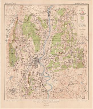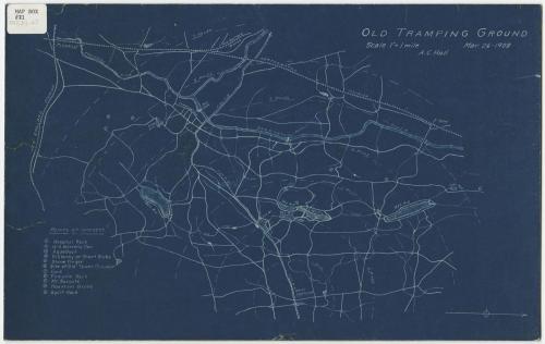
Old Tramping Ground
DraftsmanDrawn by
Amasa Clark Hall
(American, 1877 - 1922)
Date1908
MediumBlueprint; cyanotype on paper, mounted on cardboard
DimensionsPrimary Dimensions (image height x width): 8 1/2 x 13 1/2in. (21.6 x 34.3cm)
Sheet (height x width): 8 1/2 x 13 1/2in. (21.6 x 34.3cm)
Mount (height x width): 8 1/2 x 13 1/2in. (21.6 x 34.3cm)
Sheet (height x width): 8 1/2 x 13 1/2in. (21.6 x 34.3cm)
Mount (height x width): 8 1/2 x 13 1/2in. (21.6 x 34.3cm)
ClassificationsGraphics
Credit LineConnecticut Museum of Culture and History collection
DescriptionBlueprint map of West Hartford and Farmington, Connecticut, oriented east-west and featuring the Farmington River, West Hartford reservoirs 1-6, railroads and roads. The railroads include the New England Division, the Northampton Division (of the New York, New Haven and Hartford Railroad), the New Hartford Branch (of the New York, New Haven and Hartford Railroad) and the Farmington Street Railway. Concentric circles radiate out in one-mile increments from West Hartford. To the left is a "Points of Interest" list, containing eleven numbered landmarks, the locations of which have been marked on the map. Most of the features on the list are natural - Hospital Rock, Will Warren's Den, Pinnacle Rock, and more - with the remaining few being man-made towers and aqueducts.
Object number2012.312.27
NotesCartographic Note: Scale: 1 inch equals 1 mileOn View
Not on view


Kellogg & Bulkeley
1910-1915