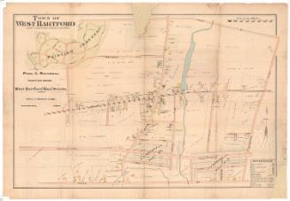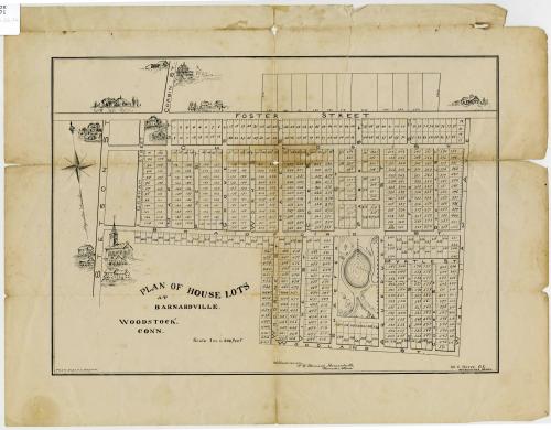
Plan of House Lots at Barnardville, Woodstock, Connecticut
DraftsmanPossibly drawn by
William C. Boyce
(American, 1852 - 1889)
Dateabout 1880
MediumLithography; black printer's ink on wove paper
DimensionsPrimary Dimensions (image height x width): 9 x 12 3/4in. (22.9 x 32.4cm)
Sheet (height x width): 12 x 15 1/2in. (30.5 x 39.4cm)
Sheet (height x width): 12 x 15 1/2in. (30.5 x 39.4cm)
ClassificationsGraphics
Credit LineConnecticut Museum of Culture and History collection
DescriptionMap of 619 numbered house lots in Barnardville, Connecticut, from Foster Street to the north, William Avenue to the west, Woodland Street to the south, and Stetson Street to the west. Some of the lots have measurements, mostly likely in feet. South of Bradford Street is a park with paths and a pond, and a broken line running through the center of the park indicates the location of an aqueduct. Within the image area, but outside of the numbered lots, are several vignettes depicting different houses and what appears to be a church. On the left side is an eight-point compass and north arrow.
Object number2012.312.26
NotesCartographic Note: Scale: 1 inch equals 200 feetOn View
Not on view
D. W. Kellogg & Co.
1830-1840